
Daïra Chlef topographic map
Interactive map
Click on the map to display elevation.
About this map
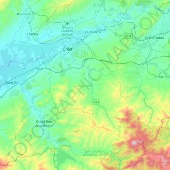
Name: Daïra Chlef topographic map, elevation, terrain.
Location: Daïra Chlef, Chlef, Algérie (35.93536 1.25950 36.25647 1.53286)
Average elevation: 1,001 ft
Minimum elevation: 236 ft
Maximum elevation: 3,825 ft
Other topographic maps
Click on a map to view its topography, its elevation and its terrain.
Sidi Salah
Algérie > Chlef > Daïra Chlef > Sendjas
Sidi Salah, Sendjas, Daïra Chlef, Chlef, Algérie
Average elevation: 1,860 ft
Mouafkia
Algérie > Chlef > Daïra Chlef > Chlef
Mouafkia, Chlef, Daïra Chlef, Chlef, 02000, Algérie
Average elevation: 476 ft
Chlef
Algérie > Chlef > Daïra Chlef
Chlef, Daïra Chlef, Chlef, 02000, Algérie
Average elevation: 587 ft