Geolocate

Caraz topographic map

Click on the map to display elevation.

Caraz

The Caraz District (Spanish: Distrito de Caraz) is one of 10 districts of the Huaylas Province in the Ancash Region of Peru. The capital of the district is Caraz. Its elevation is 2,285 m. In Caraz, the paved road comes from Pativilca.

Wikipedia (CC-BY-SA 3.0)

About this map

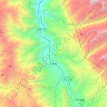
Name: Caraz topographic map, elevation, terrain.

Location: Caraz, Province of Huaylas, Ancash, Peru (-9.09696 -77.88310 -8.95140 -77.61300)

Average elevation: 11,604 ft

Minimum elevation: 6,250 ft

Maximum elevation: 20,246 ft

Other topographic maps

Click on a map to view its topography, its elevation and its terrain.

Huanzala

Peru > Ancash

Average elevation: 13,976 ft

Yamor

Peru > Ancash > Antonio Raymondi

Average elevation: 8,996 ft

Province of Huaylas

Peru > Ancash

Average elevation: 8,445 ft

San Felix

Peru > Ancash

Average elevation: 4,511 ft

Huambacho la Huaca

Peru > Ancash

Average elevation: 128 ft

Laguna Arhuaycocha

Peru > Ancash > Santa Cruz

Average elevation: 15,610 ft

Musho

Peru > Ancash > Yungay

Average elevation: 10,115 ft

Tortugas

Peru > Ancash > Comandante Noel

Average elevation: 230 ft

Ullulluco

Peru > Ancash > Alfonso Ugarte

Average elevation: 9,570 ft

Yerupajá

Peru > Ancash > Pacllón

Based on the elevation provided by the available Digital elevation models, SRTM2 (6558m with voids), SRTM filled with ASTER (6551m with voids), TanDEM-X(6110m with voids), Yerupaja is about 6635 meters above sea level. This altitude was considered due to the lack of topographic data or even handheld GPS data.

Average elevation: 18,494 ft

Rupac

Peru > Ancash > Sicsibamba

Average elevation: 10,751 ft

Inaco

Peru > Ancash > Inaco

Average elevation: 9,944 ft

Sequespampa

Peru > Ancash

Average elevation: 12,260 ft

Gear up for your next adventure:

📻Weather Alert Radios - Stay informed of storm risks while off-the-grid
🔋Rechargeable Batteries - Power up your outdoor devices
🦶Hiking Gaiters - Keep debris and water out of your boots
📌Outdoor GPS Map App - Apps and devices for digital topographic navigation
🎒Trekking Poles - Sturdy poles for balance and stability on rough terrain

As an Amazon Associate, this site earns from qualifying purchases at no extra cost to you.