
Belle Meade topographic map
Click on the map to display elevation.
About this map
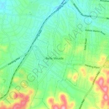
Name: Belle Meade topographic map, elevation, terrain.
Average elevation: 600 ft
Minimum elevation: 446 ft
Maximum elevation: 965 ft
Davidson County trails, hiking, mountain biking, running and outdoor activities
Other topographic maps
Click on a map to view its topography, its elevation and its terrain.
Hermitage Island
United States > Tennessee > Davidson County > Nashville-Davidson
Average elevation: 515 ft
Little Creek
United States > Tennessee > Davidson County > Nashville-Davidson
Average elevation: 636 ft
Whites Creek
United States > Tennessee > Davidson County > Nashville-Davidson
Average elevation: 469 ft
Myrtlewood Estates
United States > Tennessee > Davidson County > Nashville-Davidson
Average elevation: 676 ft
Bellshire
United States > Tennessee > Davidson County > Nashville > Bellshire
Average elevation: 610 ft
Seventeen Seventysix Estates
United States > Tennessee > Davidson County > Nashville > Seventeen Seventysix Estates
Average elevation: 653 ft
Antioch Park
United States > Tennessee > Davidson County > Nashville-Davidson > Antioch
Average elevation: 568 ft
Cherry Hills
United States > Tennessee > Davidson County > Nashville-Davidson
Average elevation: 545 ft
Colewood Acres
United States > Tennessee > Davidson County > Nashville-Davidson
Average elevation: 604 ft
Whites Creek
United States > Tennessee > Davidson County > Nashville-Davidson
Average elevation: 591 ft
Lockeland Springs Park
United States > Tennessee > Davidson County > Nashville-Davidson
Average elevation: 489 ft
Sevier Park
United States > Tennessee > Davidson County > Nashville-Davidson
Average elevation: 568 ft
Edge-O-Lake Estates
United States > Tennessee > Davidson County > Nashville-Davidson
Average elevation: 574 ft
Harpeth River
United States > Tennessee > Davidson County > Nashville-Davidson
Average elevation: 646 ft
Town Park Estates
United States > Tennessee > Davidson County > Nashville-Davidson
Average elevation: 571 ft
Tulip Grove
United States > Tennessee > Davidson County > Nashville-Davidson
Average elevation: 512 ft