
Make a donation
Gear up for your next adventure:
As an Amazon Associate, this site earns from qualifying purchases at no extra cost to you.
Cherry Hills topographic map
Click on the map to display elevation.
Make a donation
Gear up for your next adventure:
As an Amazon Associate, this site earns from qualifying purchases at no extra cost to you.
About this map
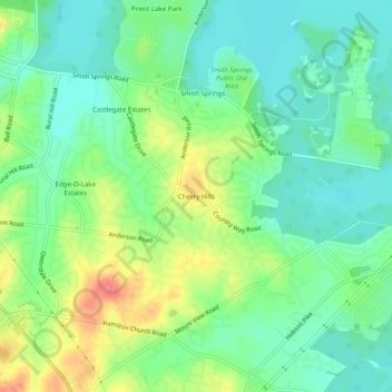
Name: Cherry Hills topographic map, elevation, terrain.
Average elevation: 545 ft
Minimum elevation: 476 ft
Maximum elevation: 669 ft
Davidson County trails, hiking, mountain biking, running and outdoor activities
Make a donation
Gear up for your next adventure:
As an Amazon Associate, this site earns from qualifying purchases at no extra cost to you.
Other topographic maps
Click on a map to view its topography, its elevation and its terrain.
Lockeland Springs Park
United States > Tennessee > Davidson County > Nashville-Davidson
Average elevation: 489 ft
Sevier Park
United States > Tennessee > Davidson County > Nashville-Davidson
Average elevation: 568 ft
Whites Creek
United States > Tennessee > Davidson County > Nashville-Davidson
Average elevation: 469 ft
Radnor Lake State Natural Area
United States > Tennessee > Davidson County > Nashville-Davidson
Average elevation: 869 ft
Make a donation
Gear up for your next adventure:
As an Amazon Associate, this site earns from qualifying purchases at no extra cost to you.
Antioch Park
United States > Tennessee > Davidson County > Nashville-Davidson > Antioch
Average elevation: 568 ft
Hermitage Island
United States > Tennessee > Davidson County > Nashville-Davidson
Average elevation: 515 ft
Harpeth River
United States > Tennessee > Davidson County > Nashville-Davidson
Average elevation: 646 ft
Make a donation
Gear up for your next adventure:
As an Amazon Associate, this site earns from qualifying purchases at no extra cost to you.
Lake Wautaga
United States > Tennessee > Davidson County > Nashville-Davidson
Average elevation: 551 ft