Make a donation
Gear up for your next adventure:
As an Amazon Associate, this site earns from qualifying purchases at no extra cost to you.
Leonia topographic map
Click on the map to display elevation.
Make a donation
Gear up for your next adventure:
As an Amazon Associate, this site earns from qualifying purchases at no extra cost to you.
Leonia
While the borough center's elevation is 115 feet (35 m), the western part of the borough can reach 5 feet (1.5 m) and the eastern part of Leonia reaches 318 feet (97 m).
Make a donation
Gear up for your next adventure:
As an Amazon Associate, this site earns from qualifying purchases at no extra cost to you.
About this map
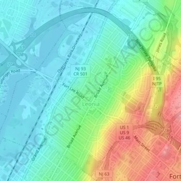
Name: Leonia topographic map, elevation, terrain.
Location: Leonia, Bergen County, New Jersey, 07605, United States (40.85088 -74.00628 40.87660 -73.97569)
Average elevation: 115 ft
Minimum elevation: -3 ft
Maximum elevation: 367 ft
Bergen County trails, hiking, mountain biking, running and outdoor activities
Make a donation
Gear up for your next adventure:
As an Amazon Associate, this site earns from qualifying purchases at no extra cost to you.
Other topographic maps
Click on a map to view its topography, its elevation and its terrain.
Ferdinands Mills
United States > New Jersey > Bergen County > Franklin Lakes
Average elevation: 423 ft
Make a donation
Gear up for your next adventure:
As an Amazon Associate, this site earns from qualifying purchases at no extra cost to you.
Make a donation
Gear up for your next adventure:
As an Amazon Associate, this site earns from qualifying purchases at no extra cost to you.
Make a donation
Gear up for your next adventure:
As an Amazon Associate, this site earns from qualifying purchases at no extra cost to you.
Ridgefield Park
United States > New Jersey > Bergen County > Ridgefield Park > Ridgefield Park
Average elevation: 69 ft
Make a donation
Gear up for your next adventure:
As an Amazon Associate, this site earns from qualifying purchases at no extra cost to you.
Glen Rock
United States > New Jersey > Bergen County > Glen Rock > Glen Rock
Average elevation: 171 ft
Hillsdale
United States > New Jersey > Bergen County > Hillsdale > Hillsdale
Average elevation: 131 ft
Make a donation
Gear up for your next adventure:
As an Amazon Associate, this site earns from qualifying purchases at no extra cost to you.
