
Make a donation
Gear up for your next adventure:
As an Amazon Associate, this site earns from qualifying purchases at no extra cost to you.
Mazapil topographic map
Click on the map to display elevation.
Make a donation
Gear up for your next adventure:
As an Amazon Associate, this site earns from qualifying purchases at no extra cost to you.
Mazapil
Mazapil is situated in the Chihuahuan Desert and has an elevation range between 1,300 and 3,200 metres (4,300–10,500 ft). Matorral vegetation predominates in the mostly arid and semi-arid climate, although open pinyon-juniper woodlands occur in the more elevated regions with their more temperate and partially sub-humid climates. Average annual precipitation in the municipality varies between 200 and 600 millimetres (7.9–23.6 in).
Make a donation
Gear up for your next adventure:
As an Amazon Associate, this site earns from qualifying purchases at no extra cost to you.
About this map
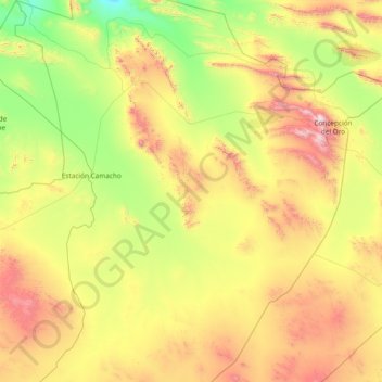
Name: Mazapil topographic map, elevation, terrain.
Location: Mazapil, Zacatecas, Mexico (23.69370 -102.67306 25.06664 -101.19250)
Average elevation: 6,188 ft
Minimum elevation: 4,278 ft
Maximum elevation: 10,328 ft
Make a donation
Gear up for your next adventure:
As an Amazon Associate, this site earns from qualifying purchases at no extra cost to you.
Other topographic maps
Click on a map to view its topography, its elevation and its terrain.
Zacatecas City
Mexico > Zacatecas > Municipio de Zacatecas
The municipality is wedged between the Sierra Madre Occidental and the subrange called Sierras y Valles Zacatecanos. The area is very rugged terrain filled with narrow valleys, ravines and mountains. The principal elevations include Cerro El Grillo at 2,690 m (8,830 ft), Cerro Los Alamitos at 2,680 m (8,790…
Average elevation: 7,513 ft
Make a donation
Gear up for your next adventure:
As an Amazon Associate, this site earns from qualifying purchases at no extra cost to you.
La Laguna (La Laguna Valenciana)
Mexico > Zacatecas > General Francisco R. Murguía
Average elevation: 6,719 ft
Make a donation
Gear up for your next adventure:
As an Amazon Associate, this site earns from qualifying purchases at no extra cost to you.
Cinco Hermanos (José Luis Alba) [Rancho]
Mexico > Zacatecas > Fresnillo > José María Morelos
Average elevation: 6,696 ft
Zacatecas City
Mexico > Zacatecas > Municipio de Zacatecas
The municipality is wedged between the Sierra Madre Occidental and the subrange called Sierras y Valles Zacatecanos. The area is very rugged terrain filled with narrow valleys, ravines and mountains. The principal elevations include Cerro El Grillo at 2,690 m (8,830 ft), Cerro Los Alamitos at 2,680 m (8,790…
Average elevation: 7,513 ft
Make a donation
Gear up for your next adventure:
As an Amazon Associate, this site earns from qualifying purchases at no extra cost to you.
Sombrerete
Mexico > Zacatecas > Sombrerete
The region is between the Sierra Madre Occidental and the central highlands of Mexico. The municipality is in a valley is surrounded on all sides by small mountain ranges such as the Sierra de Sombrerete and the Sierra de Santa María with prominent elevations such as the Cerro Grande, Cerro Reyes, Cerro…
Average elevation: 7,877 ft
Make a donation
Gear up for your next adventure:
As an Amazon Associate, this site earns from qualifying purchases at no extra cost to you.