Geolocate

Bandera topographic map

Click on the map to display elevation.

About this map

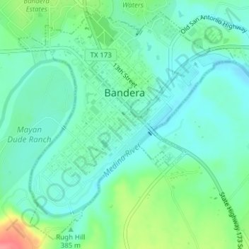
Name: Bandera topographic map, elevation, terrain.

Location: Bandera, Bandera County, Texas, 78003, United States (29.71105 -99.08574 29.73599 -99.05856)

Average elevation: 1,263 ft

Minimum elevation: 1,194 ft

Maximum elevation: 1,450 ft

Bandera County trails, hiking, mountain biking, running and outdoor activities

Other topographic maps

Click on a map to view its topography, its elevation and its terrain.

Tarpley

United States > Texas > Bandera County

Average elevation: 1,381 ft

Medina

United States > Texas > Bandera County

Average elevation: 1,483 ft

Vanderpool

United States > Texas > Bandera County

Average elevation: 1,719 ft

Chalk Mountain

United States > Texas > Bandera County

Average elevation: 1,696 ft

Gallant Lake Dam

United States > Texas > Bandera County

Average elevation: 1,726 ft

Gear up for your next adventure:

📶Satellite Messenger - Communication device off‑grid
💧Water Purification System - Clean water on the trail with reliable purifiers
🛠️Backpacking Tool Kit - Essential toolkit for outdoor repairs
🥇GPS Hiking Watch - Multi‑sport GPS watch with navigation and trail tracking
😴Insulated Sleeping Pads - Compact and warm pads for high-elevation camping

As an Amazon Associate, this site earns from qualifying purchases at no extra cost to you.