
Annapolis topographic map
Click on the map to display elevation.
About this map
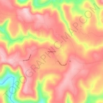
Name: Annapolis topographic map, elevation, terrain.
Location: Annapolis, Sonoma County, California, United States (38.70186 -123.38973 38.74186 -123.34973)
Average elevation: 659 ft
Minimum elevation: 62 ft
Maximum elevation: 948 ft
Sonoma County trails, hiking, mountain biking, running and outdoor activities
Other topographic maps
Click on a map to view its topography, its elevation and its terrain.
Eldridge
United States > California > Sonoma County > Eldridge > Agua Caliente
Average elevation: 249 ft
Graton
United States > California > Sonoma County > Graton
Graton is located at the southeastern end of Green Valley, on the east bank of the seasonally flooding Atascadero Creek. The elevation ranges from approximately 85 feet (26 m) above Mean Sea Level (MSL) at Atascadero Creek to 213 feet (65 m) MSL at Oak Grove School.
Average elevation: 164 ft
Boyes Hot Springs
United States > California > Sonoma County > Boyes Hot Springs > Verano
Average elevation: 171 ft
Russian River
United States > California > Sonoma County > Guerneville > El Bonita
The geographer R. S. Holway wrote of the Russian River in his 1917 paper "The Russian River: A Characteristic Stream of the California Coast Ranges". Originally, the Russian River was one of several rivers draining westward from the Mayacamas Mountains through the Mendocino Plateau to the sea, a region lifted…
Average elevation: 591 ft
Sebastopol
United States > California > Sonoma County
Sebastopol's elevation is 65 to 250 feet (20 to 76 meters) above sea level. Its downtown is at the intersection of State Route 12 and State Route 116 (Gravenstein Highway), approximately 9 mi (14 km) west of U.S. Route 101.
Average elevation: 226 ft
Sebastopol
United States > California > Sonoma County
Sebastopol's elevation is 65 to 250 feet (20 to 76 meters) above sea level. Its downtown is at the intersection of State Route 12 and State Route 116 (Gravenstein Highway), approximately 9 mi (14 km) west of U.S. Route 101.
Average elevation: 157 ft