
Mali Prefecture topographic map
Interactive map
Click on the map to display elevation.
About this map
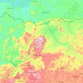
Name: Mali Prefecture topographic map, elevation, terrain.
Location: Mali Prefecture, Labé Region, Guinea (11.64625 -12.84095 12.45264 -11.36493)
Average elevation: 1,437 ft
Minimum elevation: 121 ft
Maximum elevation: 4,921 ft
Other topographic maps
Click on a map to view its topography, its elevation and its terrain.
Tougué Prefecture
Tougué Prefecture, Labé Region, Guinea
Average elevation: 2,037 ft
Lelouma Prefecture
Lelouma Prefecture, Labé Region, Guinea
Average elevation: 2,247 ft
Koubia Prefecture
Koubia Prefecture, Labé Region, Guinea
Average elevation: 2,024 ft
Kerouane
Guinea > Labé Region > Mali Prefecture
Kerouane, Mali Prefecture, Labé Region, Guinea
Average elevation: 1,490 ft
Mali
Guinea > Labé Region > Mali Prefecture
Mali, Mali Prefecture, Labé Region, Guinea
Average elevation: 4,304 ft