
Labé Prefecture topographic map
Interactive map
Click on the map to display elevation.
About this map
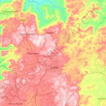
Name: Labé Prefecture topographic map, elevation, terrain.
Location: Labé Prefecture, Labé Region, Guinea (11.12198 -12.59990 11.68459 -11.99691)
Average elevation: 2,871 ft
Minimum elevation: 1,362 ft
Maximum elevation: 4,213 ft
Other topographic maps
Click on a map to view its topography, its elevation and its terrain.
Tougué Prefecture
Tougué Prefecture, Labé Region, Guinea
Average elevation: 2,037 ft
Lelouma Prefecture
Lelouma Prefecture, Labé Region, Guinea
Average elevation: 2,247 ft
Koubia Prefecture
Koubia Prefecture, Labé Region, Guinea
Average elevation: 2,024 ft
Kerouane
Guinea > Labé Region > Mali Prefecture
Kerouane, Mali Prefecture, Labé Region, Guinea
Average elevation: 1,490 ft
Mali
Guinea > Labé Region > Mali Prefecture
Mali, Mali Prefecture, Labé Region, Guinea
Average elevation: 4,304 ft