Geolocate

Mono Department topographic map

Interactive map

Click on the map to display elevation.

About this map

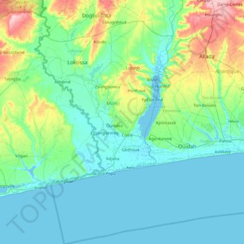
Name: Mono Department topographic map, elevation, terrain.

Location: Mono Department, Benin (6.23514 1.57506 6.78249 2.03722)

Average elevation: 89 ft

Minimum elevation: -10 ft

Maximum elevation: 453 ft

Mono Department is located in the southwest of Benin and border Kouffo Department to the north, Atlantique Department to the east, the Atlantic Ocean to the south, and Togo to the west. It is located in a coastal area that has interconnected lakes and lagoons and elongated coastlines with wide marshes. Lake Ahémé, Benin's second largest lake, lies on the border with the Atlantique Department; smaller lakes in the department include Lake Toho and Lake Togbadji. The southern regions of Benin receive two spells from March to July and September to November while the northern regions of the country receive one season of rainfall from May to September. The country receives an average annual rainfall of around 1,200 mm (47 in), but Mono Department receives less rainfall. The department has mostly low-lying sandy coastal plains towards the Atlantic Ocean, marshes, lagoons and lakes. The highest elevation in the department around the coastal plains is 20 m (66 ft) compared to the average 200 m (660 ft) above average mean sea level of the country.

Wikipedia (CC-BY-SA 3.0)

Other topographic maps

Click on a map to view its topography, its elevation and its terrain.

Abomey-Calavi

Benin > Atlantique Department > Abomey-Calavi

Abomey-Calavi, Atlantique Department, Benin

Average elevation: 43 ft

Tanguieta

Benin > Atakora Department > Tanguièta

Tanguieta, Tanguièta, Atakora Department, Benin

Average elevation: 961 ft

Serou

Benin > Borgou Department > Sinendé

Serou, Sinendé, Borgou Department, Benin

Average elevation: 1,181 ft

Atakora Department

Benin

Atakora Department, Benin

Average elevation: 978 ft

Atlantique Department

Benin

Atlantique Department, Benin

Average elevation: 128 ft

Donga Department

Benin

Donga Department, Benin

Average elevation: 1,135 ft

Plateau Department

Benin

Plateau Department, Benin

Average elevation: 282 ft

Kouffo Department

Benin

Kouffo Department, Benin

Average elevation: 397 ft

Alibori Department

Benin

Alibori Department, Benin

Average elevation: 863 ft

Ouémé Department

Benin

Ouémé Department, Benin

Average elevation: 141 ft

Zou Department

Benin

Zou Department, Benin

Average elevation: 354 ft

Cotonou

Benin > Littoral

Cotonou, Littoral, Benin

Average elevation: 7 ft

Collines

Benin > Collines

Collines, Benin

Average elevation: 669 ft

Okéo

Benin > Collines > Okéo

Okéo, Glazoué, Collines, Benin

Average elevation: 568 ft

Cotonou

Benin > Littoral > Cotonou

Cotonou, 7ème Arrondissement, Cotonou, Littoral, 05BP1063 COTONOU- BENIN, Benin

Average elevation: 13 ft

Koléa

Benin > Alibori > Kandi

Koléa, Kandi, Alibori, Benin

Average elevation: 830 ft

Littoral

Benin

Littoral, Benin

Average elevation: 7 ft

Tanguièta

Benin > Atakora Department > Tanguièta

Tanguièta, Atakora Department, Benin

Average elevation: 883 ft

Yarra

Benin > Borgou > Yarra

Yarra, Sinendé, Borgou, Benin

Average elevation: 1,135 ft

Porto-Novo

Benin > Ouémé Department > Porto Novo

Porto-Novo, Porto Novo, Ouémé Department, Benin

Average elevation: 49 ft