
Make a donation
Gear up for your next adventure:
As an Amazon Associate, this site earns from qualifying purchases at no extra cost to you.
New Hill topographic map
Click on the map to display elevation.
Make a donation
Gear up for your next adventure:
As an Amazon Associate, this site earns from qualifying purchases at no extra cost to you.
About this map
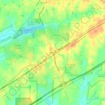
Name: New Hill topographic map, elevation, terrain.
Location: New Hill, Wake County, North Carolina, United States (35.66099 -78.95557 35.70099 -78.91557)
Average elevation: 305 ft
Minimum elevation: 236 ft
Maximum elevation: 371 ft
Wake County trails, hiking, mountain biking, running and outdoor activities
Make a donation
Gear up for your next adventure:
As an Amazon Associate, this site earns from qualifying purchases at no extra cost to you.
Other topographic maps
Click on a map to view its topography, its elevation and its terrain.
Knightdale Station Park
United States > North Carolina > Wake County > Knightdale
Average elevation: 315 ft
Shearon Harris Auxiliary Reservoir Dam
United States > North Carolina > Wake County
Average elevation: 259 ft
Make a donation
Gear up for your next adventure:
As an Amazon Associate, this site earns from qualifying purchases at no extra cost to you.
City of Raleigh
United States > North Carolina > Wake County > City of Raleigh
Average elevation: 446 ft