
Fareham topographic map
Click on the map to display elevation.
About this map
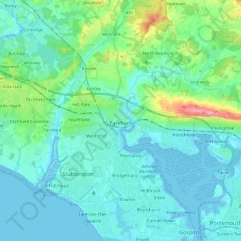
Name: Fareham topographic map, elevation, terrain.
Location: Fareham, Hampshire, England, United Kingdom (50.80894 -1.31291 50.89901 -1.11229)
Average elevation: 69 ft
Minimum elevation: -13 ft
Maximum elevation: 420 ft
Other topographic maps
Click on a map to view its topography, its elevation and its terrain.
Basingstoke
United Kingdom > England > Hampshire > Basingstoke and Deane
Situated in a valley through the Hampshire Downs at an average elevation of 88 metres (289 ft) Basingstoke is a major interchange between Reading, Newbury, Andover, Winchester, and Alton, and lies on the natural trade route between the southwest of England and London. The area had been something of an…
Average elevation: 358 ft
Portsmouth
United Kingdom > England > Hampshire > Portsmouth
By road, Portsmouth lies 73.5 miles (118.3 km) from Central London, 49.5 miles (79.7 km) west of Brighton, and 22.3 miles (35.9 km) east of Southampton. Portsmouth is situated primarily on Portsea Island and is the United Kingdom's only island city, although parts of it have expanded onto the mainland. Gosport…
Average elevation: 92 ft
Farnborough
United Kingdom > England > Hampshire > Rushmoor
Farnborough is located in the northeastern corner of the county of Hampshire, near the border with Surrey. The town occupies a valley setting, with the main urban area situated between the River Blackwater to the east and higher ground to the west. The topography gradually rises from the valley floor, reaching…
Average elevation: 269 ft
River Lyde
United Kingdom > England > Hampshire > Basingstoke and Deane > Up Nately
Average elevation: 256 ft
Warwick Slade
United Kingdom > England > Hampshire > New Forest > Lyndhurst > Allum Green
Average elevation: 118 ft
Old Winchester Hill Iron Age Fort
United Kingdom > England > Hampshire > Winchester
Average elevation: 404 ft
Neatham
United Kingdom > England > Hampshire > East Hampshire > Alton > Holybourne
Average elevation: 400 ft
Middle Wallop
United Kingdom > England > Hampshire > Test Valley > Over Wallop
Average elevation: 262 ft
Winterhill Plantation
United Kingdom > England > Hampshire > Basingstoke and Deane > Whitchurch > Wells-In-The-Field
Average elevation: 328 ft
Liphook
United Kingdom > England > Hampshire > East Hampshire
In Samuel Lewis's 1831 Topographical Dictionary of England, he referred to Liphook as a hamlet in the parish of Bramshott.
Average elevation: 397 ft
Rowland's Copse, Red Hill
United Kingdom > England > Hampshire > East Hampshire > Rowlands Castle
Average elevation: 138 ft
Withering Corner
United Kingdom > England > Hampshire > Test Valley > Ashley
Average elevation: 394 ft
Morgaston Wood
United Kingdom > England > Hampshire > Basingstoke and Deane > Sherborne St John
Average elevation: 249 ft
Sherborne St John
United Kingdom > England > Hampshire > Basingstoke and Deane
Average elevation: 302 ft
Highclere Castle
United Kingdom > England > Hampshire > Basingstoke and Deane
Average elevation: 545 ft
News Wood
United Kingdom > England > Hampshire > Test Valley > King's Somborne
Average elevation: 305 ft
Cold Ash Hill
United Kingdom > England > Hampshire > East Hampshire > Bramshott
Average elevation: 413 ft
Bath Meadows
United Kingdom > England > Hampshire > Test Valley > Wellow > East Wellow
Average elevation: 98 ft
Leigh Road Recreation Ground
United Kingdom > England > Hampshire > Eastleigh
Average elevation: 56 ft
Hartley Mauditt
United Kingdom > England > Hampshire > East Hampshire > Hartley Mauditt
Average elevation: 404 ft
Normandy Barracks
United Kingdom > England > Hampshire > Rushmoor > Farnborough
Average elevation: 249 ft
South Baddesley
United Kingdom > England > Hampshire > New Forest > Norleywood
Average elevation: 43 ft
Bickton
United Kingdom > England > Hampshire > New Forest > Fordingbridge > Bickton
Average elevation: 128 ft
Brambridge
United Kingdom > England > Hampshire > Winchester > Colden Common > Brambridge
Average elevation: 121 ft
Basingstoke
United Kingdom > England > Hampshire > Basingstoke and Deane
Situated in a valley through the Hampshire Downs at an average elevation of 88 metres (289 ft) Basingstoke is a major interchange between Reading, Newbury, Andover, Winchester, and Alton, and lies on the natural trade route between the southwest of England and London. The area had been something of an…
Average elevation: 351 ft
Charlton Down
United Kingdom > England > Hampshire > Test Valley > Wildhern > Charlton Down
Average elevation: 364 ft
Chilton Candover
United Kingdom > England > Hampshire > Basingstoke and Deane > Chilton Candover
Average elevation: 387 ft