
Shuswap topographic map
Click on the map to display elevation.
About this map
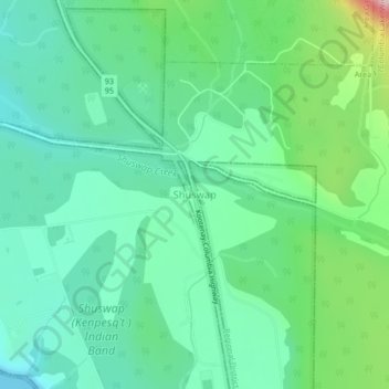
Name: Shuswap topographic map, elevation, terrain.
Average elevation: 3,038 ft
Minimum elevation: 2,602 ft
Maximum elevation: 5,400 ft
Other topographic maps
Click on a map to view its topography, its elevation and its terrain.
Whiteswan Lake
Canada > British Columbia > Regional District of East Kootenay > Area F (Columbia Lake/Windermere Lake)
Average elevation: 4,567 ft
Windermere Lake
Canada > British Columbia > Regional District of East Kootenay > Area F (Columbia Lake/Windermere Lake) > Windermere
Average elevation: 3,314 ft
Findlay Creek
Canada > British Columbia > Regional District of East Kootenay > Area F (Columbia Lake/Windermere Lake)
Average elevation: 4,167 ft
Whiteswan Lake Provincial Park
Canada > British Columbia > Regional District of East Kootenay > Area F (Columbia Lake/Windermere Lake)
Average elevation: 5,469 ft
Columbia Lake
Canada > British Columbia > Regional District of East Kootenay > Area F (Columbia Lake/Windermere Lake)
Average elevation: 4,098 ft