
Hansaviertel topographic map
Interactive map
Click on the map to display elevation.
About this map
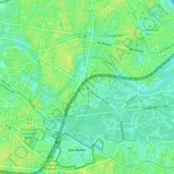
Name: Hansaviertel topographic map, elevation, terrain.
Location: Hansaviertel, Mitte, Berlin, Allemagne (52.51378 13.33421 52.52267 13.35032)
Average elevation: 128 ft
Minimum elevation: 102 ft
Maximum elevation: 151 ft
Other topographic maps
Click on a map to view its topography, its elevation and its terrain.
Charlottenburg-Wilmersdorf
Charlottenburg-Wilmersdorf, Berlin, Allemagne
Average elevation: 144 ft
Mariendorf
Mariendorf, Tempelhof-Schöneberg, Berlin, Allemagne
Average elevation: 154 ft