Geolocate

Oak Ridges topographic map

Click on the map to display elevation.

About this map

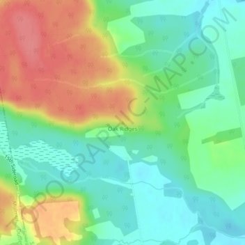
Name: Oak Ridges topographic map, elevation, terrain.

Location: Oak Ridges, Adjala–Tosorontio, New Tecumseth, Simcoe County, Central Ontario, Ontario, L0M 1J0, Canada (44.20083 -79.99325 44.20093 -79.99315)

Average elevation: 883 ft

Minimum elevation: 784 ft

Maximum elevation: 1,030 ft

Other topographic maps

Click on a map to view its topography, its elevation and its terrain.

Gear up for your next adventure:

🪓Survival Multi‑Tool - Versatile tool for camp and trail tasks
🔭Telescopic Hiking Pole - Adjustable pole for hiking stability
🪶Compact Camp Shovel - Folding shovel for campsite tasks
🪶Thermal Camp Blanket - Extra warmth for cold nights
🛡️Insect Repellent - Protection against bugs during outdoor activities

As an Amazon Associate, this site earns from qualifying purchases at no extra cost to you.