Geolocate

Walker topographic map

Click on the map to display elevation.

About this map

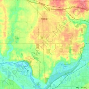
Name: Walker topographic map, elevation, terrain.

Location: Walker, Kent County, Michigan, United States (42.91066 -85.78859 43.03088 -85.66062)

Average elevation: 686 ft

Minimum elevation: 581 ft

Maximum elevation: 846 ft

Kent County trails, hiking, mountain biking, running and outdoor activities

Other topographic maps

Click on a map to view its topography, its elevation and its terrain.

Harvard Lake

United States > Michigan > Kent County > Harvard

Average elevation: 876 ft

Grattan

United States > Michigan > Kent County

Average elevation: 856 ft

Lookout Park

United States > Michigan > Kent County > Grand Rapids

Average elevation: 669 ft

Crescent Park

United States > Michigan > Kent County > Grand Rapids

Average elevation: 669 ft

Kettle Lake

United States > Michigan > Kent County

Average elevation: 784 ft

Cobb Lake

United States > Michigan > Kent County > Bowne Township

Average elevation: 827 ft

Grattan

United States > Michigan > Kent County

Average elevation: 856 ft

Parnell

United States > Michigan > Kent County > Grattan Township

Average elevation: 850 ft

Richmond Park

United States > Michigan > Kent County > Grand Rapids

Average elevation: 663 ft

Creekside Park

United States > Michigan > Kent County > Lowell

Average elevation: 659 ft

Gear up for your next adventure:

🧭Pro Hiking Compasses - High-accuracy liquid-filled compasses for topographic orientation
🚗GPS Dash Cams - Record your scenic drives through mountain passes and canyons
Backpacking Tents - Weight-optimized shelters for multi-day topographic surveys
🧣Merino Neck Gaiters - Multi-functional headwear for wind and sun protection
🔋Rechargeable Batteries - Power up your outdoor devices

As an Amazon Associate, this site earns from qualifying purchases at no extra cost to you.