
Make a donation
Gear up for your next adventure:
As an Amazon Associate, this site earns from qualifying purchases at no extra cost to you.
Three Oaks topographic map
Click on the map to display elevation.
Make a donation
Gear up for your next adventure:
As an Amazon Associate, this site earns from qualifying purchases at no extra cost to you.
About this map
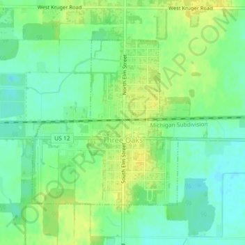
Name: Three Oaks topographic map, elevation, terrain.
Location: Three Oaks, Berrien County, Michigan, United States (41.79144 -86.62404 41.80966 -86.60243)
Average elevation: 666 ft
Minimum elevation: 633 ft
Maximum elevation: 699 ft
Berrien County trails, hiking, mountain biking, running and outdoor activities
Make a donation
Gear up for your next adventure:
As an Amazon Associate, this site earns from qualifying purchases at no extra cost to you.
Other topographic maps
Click on a map to view its topography, its elevation and its terrain.
Grand Mere State Park
United States > Michigan > Berrien County > Lincoln Charter Township
Average elevation: 607 ft
Make a donation
Gear up for your next adventure:
As an Amazon Associate, this site earns from qualifying purchases at no extra cost to you.
Grand Mere State Park
United States > Michigan > Berrien County > Lincoln Charter Township
Average elevation: 607 ft
Grand Mere State Park
United States > Michigan > Berrien County > Stevensville
Average elevation: 607 ft
Grand Mere State Park
United States > Michigan > Berrien County > Stevensville
Average elevation: 607 ft
Make a donation
Gear up for your next adventure:
As an Amazon Associate, this site earns from qualifying purchases at no extra cost to you.
Make a donation
Gear up for your next adventure:
As an Amazon Associate, this site earns from qualifying purchases at no extra cost to you.