
Make a donation
Gear up for your next adventure:
As an Amazon Associate, this site earns from qualifying purchases at no extra cost to you.
Turtle Creek topographic map
Click on the map to display elevation.
Make a donation
Gear up for your next adventure:
As an Amazon Associate, this site earns from qualifying purchases at no extra cost to you.
About this map
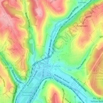
Name: Turtle Creek topographic map, elevation, terrain.
Average elevation: 938 ft
Minimum elevation: 722 ft
Maximum elevation: 1,178 ft
Allegheny County trails, hiking, mountain biking, running and outdoor activities
Make a donation
Gear up for your next adventure:
As an Amazon Associate, this site earns from qualifying purchases at no extra cost to you.
Other topographic maps
Click on a map to view its topography, its elevation and its terrain.
New England
United States > Pennsylvania > Allegheny County > West Mifflin
Average elevation: 1,093 ft
Morgan
United States > Pennsylvania > Allegheny County > South Fayette Township
Average elevation: 1,030 ft
Rural Ridge
United States > Pennsylvania > Allegheny County > Indiana Township
Average elevation: 1,079 ft
Make a donation
Gear up for your next adventure:
As an Amazon Associate, this site earns from qualifying purchases at no extra cost to you.
Cuddy Hill
United States > Pennsylvania > Allegheny County > South Fayette Township
Average elevation: 1,076 ft
Indianola
United States > Pennsylvania > Allegheny County > Indiana Township
Average elevation: 1,014 ft
Rennerdale
United States > Pennsylvania > Allegheny County > Collier Township
Average elevation: 1,053 ft
Noblestown
United States > Pennsylvania > Allegheny County > North Fayette Township
Average elevation: 1,089 ft
Make a donation
Gear up for your next adventure:
As an Amazon Associate, this site earns from qualifying purchases at no extra cost to you.
Industry
United States > Pennsylvania > Allegheny County > Elizabeth Township
Average elevation: 958 ft
Greenock
United States > Pennsylvania > Allegheny County > Elizabeth Township
Average elevation: 945 ft
Enlow
United States > Pennsylvania > Allegheny County > North Fayette Township
Average elevation: 1,079 ft
Make a donation
Gear up for your next adventure:
As an Amazon Associate, this site earns from qualifying purchases at no extra cost to you.
Dorseyville
United States > Pennsylvania > Allegheny County > Indiana Township
Average elevation: 1,066 ft
Allison Park
United States > Pennsylvania > Allegheny County > Hampton Township
Average elevation: 1,063 ft
Bairdford
United States > Pennsylvania > Allegheny County > West Deer Township
Average elevation: 1,079 ft
Make a donation
Gear up for your next adventure:
As an Amazon Associate, this site earns from qualifying purchases at no extra cost to you.
Buena Vista
United States > Pennsylvania > Allegheny County > Elizabeth Township
Average elevation: 955 ft
Beadling
United States > Pennsylvania > Allegheny County > Upper St. Clair
Average elevation: 1,070 ft
Make a donation
Gear up for your next adventure:
As an Amazon Associate, this site earns from qualifying purchases at no extra cost to you.
Groveton
United States > Pennsylvania > Allegheny County > Robinson Township
Average elevation: 876 ft
Ruthfred Acres
United States > Pennsylvania > Allegheny County > Bethel Park
Average elevation: 1,142 ft
Make a donation
Gear up for your next adventure:
As an Amazon Associate, this site earns from qualifying purchases at no extra cost to you.
Gibsonia
United States > Pennsylvania > Allegheny County > Richland Township
Average elevation: 1,142 ft
Wildwood
United States > Pennsylvania > Allegheny County > Hampton Township
Average elevation: 1,079 ft
Make a donation
Gear up for your next adventure:
As an Amazon Associate, this site earns from qualifying purchases at no extra cost to you.
Panther Hollow Lake
United States > Pennsylvania > Allegheny County > Pittsburgh
Average elevation: 938 ft
Santiago
United States > Pennsylvania > Allegheny County > North Fayette Township
Average elevation: 1,161 ft
Make a donation
Gear up for your next adventure:
As an Amazon Associate, this site earns from qualifying purchases at no extra cost to you.
Lovedale
United States > Pennsylvania > Allegheny County > Elizabeth Township
Average elevation: 978 ft
Mount Vernon
United States > Pennsylvania > Allegheny County > Elizabeth Township
Average elevation: 981 ft
Make a donation
Gear up for your next adventure:
As an Amazon Associate, this site earns from qualifying purchases at no extra cost to you.
Talley Cavey
United States > Pennsylvania > Allegheny County > Hampton Township
Average elevation: 1,119 ft
Piney Fork
United States > Pennsylvania > Allegheny County > South Park Township
Average elevation: 1,066 ft
Make a donation
Gear up for your next adventure:
As an Amazon Associate, this site earns from qualifying purchases at no extra cost to you.
Fox Ridge
United States > Pennsylvania > Allegheny County > McCandless > Fox Ridge
Average elevation: 1,145 ft
Black mulberry (Morus nigra)
United States > Pennsylvania > Allegheny County > Pittsburgh
Average elevation: 971 ft
Make a donation
Gear up for your next adventure:
As an Amazon Associate, this site earns from qualifying purchases at no extra cost to you.
Elfinwild
United States > Pennsylvania > Allegheny County > Shaler Township
Average elevation: 1,056 ft