
Make a donation
Gear up for your next adventure:
As an Amazon Associate, this site earns from qualifying purchases at no extra cost to you.
Atauro topographic map
Click on the map to display elevation.
Make a donation
Gear up for your next adventure:
As an Amazon Associate, this site earns from qualifying purchases at no extra cost to you.
Atauro
The landscape of the island is a result of the erosion of uplifted, originally submarine, volcanos from the Neogene period creating narrow, dissected ridges and steep slopes. Up to an elevation of about 600 m there are also extensive areas of uplifted coralline limestone. The climate is distinctly seasonal, with wet and dry seasons. The island has suffered from extensive clearing of its native vegetation for swidden agriculture. The upper levels of Mount Manucoco (above 700 m) still carry patches of tropical semi-evergreen mountain forest in sheltered valleys, covering about 40 km2. Lower down there are remnants of drier forest and Eucalyptus alba dominated savanna woodlands, especially on limestone outcrops, with agricultural land in the vicinity of villages. The island has a fringing reef 30–150 m in width; it generally lacks freshwater wetlands, estuaries and mangroves. In 2016 a Conservation International team found more species of reef fish per site in the waters surrounding the island than anywhere else in the world.
Make a donation
Gear up for your next adventure:
As an Amazon Associate, this site earns from qualifying purchases at no extra cost to you.
About this map
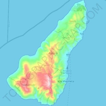
Name: Atauro topographic map, elevation, terrain.
Location: Atauro, East Timor (-8.30883 125.50112 -8.12690 125.64390)
Average elevation: 354 ft
Minimum elevation: 0 ft
Maximum elevation: 3,173 ft
Make a donation
Gear up for your next adventure:
As an Amazon Associate, this site earns from qualifying purchases at no extra cost to you.
Other topographic maps
Click on a map to view its topography, its elevation and its terrain.
Same
The city is located in the interior of the island, 49 kilometres (30 mi) south of the provincial capital of Dili, at an altitude of 384 metres (1,260 ft), south of the mountain Cabalaki (Foho Kabulaki). The centre is located in the Suco Letefoho in which are situated the districts Ria-Lau (Rialau) Manico 1, 2…
Average elevation: 1,742 ft
Make a donation
Gear up for your next adventure:
As an Amazon Associate, this site earns from qualifying purchases at no extra cost to you.