
Make a donation
Gear up for your next adventure:
As an Amazon Associate, this site earns from qualifying purchases at no extra cost to you.
Sugarloaf Township topographic map
Click on the map to display elevation.
Make a donation
Gear up for your next adventure:
As an Amazon Associate, this site earns from qualifying purchases at no extra cost to you.
Sugarloaf Township
Sugarloaf Township is located in the northeast corner of Columbia County, and is bordered to the north by Sullivan County and to the east by Luzerne County. Most of the township is rolling hills, with elevations ranging from 850 to 1,300 feet (260 to 400 m), while the northern part of the township contains the southern escarpment of the Allegheny Plateau, with elevations rising to 2,341 feet (714 m) along Huckleberry Mountain in the west, to 2,250 feet (690 m) on Central Mountain to the east, and to 2,360 feet (720 m) on Red Rock Mountain in the northeastern corner.
Make a donation
Gear up for your next adventure:
As an Amazon Associate, this site earns from qualifying purchases at no extra cost to you.
About this map
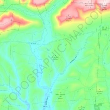
Name: Sugarloaf Township topographic map, elevation, terrain.
Average elevation: 1,289 ft
Minimum elevation: 823 ft
Maximum elevation: 2,434 ft
Columbia County trails, hiking, mountain biking, running and outdoor activities
Make a donation
Gear up for your next adventure:
As an Amazon Associate, this site earns from qualifying purchases at no extra cost to you.
Other topographic maps
Click on a map to view its topography, its elevation and its terrain.
Mifflin Cross Roads
United States > Pennsylvania > Columbia County > Beaver Township
Average elevation: 1,024 ft
Make a donation
Gear up for your next adventure:
As an Amazon Associate, this site earns from qualifying purchases at no extra cost to you.
Byrnesville
United States > Pennsylvania > Columbia County > Conyngham Township
Average elevation: 1,325 ft
Hemlock Creek
United States > Pennsylvania > Columbia County > Buckhorn > Buckhorn
Average elevation: 679 ft