
Make a donation
Gear up for your next adventure:
As an Amazon Associate, this site earns from qualifying purchases at no extra cost to you.
Homedale topographic map
Click on the map to display elevation.
Make a donation
Gear up for your next adventure:
As an Amazon Associate, this site earns from qualifying purchases at no extra cost to you.
Homedale
Homedale is located at 43°37′8″N 116°56′13″W / 43.61889°N 116.93694°W / 43.61889; -116.93694 (43.618980, −116.936836), at an elevation of 2,231 feet (680 m) above sea level. The city is on the Snake River, which is the border with Canyon County.
Make a donation
Gear up for your next adventure:
As an Amazon Associate, this site earns from qualifying purchases at no extra cost to you.
About this map
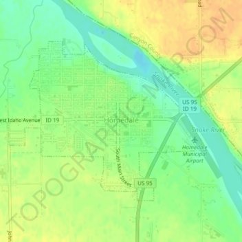
Name: Homedale topographic map, elevation, terrain.
Location: Homedale, Owyhee County, Idaho, 83628, United States (43.60864 -116.95120 43.62644 -116.92054)
Average elevation: 2,241 ft
Minimum elevation: 2,185 ft
Maximum elevation: 2,287 ft
Owyhee County trails, hiking, mountain biking, running and outdoor activities
Make a donation
Gear up for your next adventure:
As an Amazon Associate, this site earns from qualifying purchases at no extra cost to you.
Other topographic maps
Click on a map to view its topography, its elevation and its terrain.