
Gaither topographic map
Click on the map to display elevation.
About this map
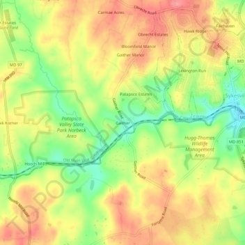
Name: Gaither topographic map, elevation, terrain.
Location: Gaither, Carroll County, Maryland, 21784, United States (39.34149 -77.01303 39.38149 -76.97303)
Average elevation: 528 ft
Minimum elevation: 364 ft
Maximum elevation: 656 ft
Carroll County trails, hiking, mountain biking, running and outdoor activities
Other topographic maps
Click on a map to view its topography, its elevation and its terrain.
Avondale Wildlife Management Area
United States > Maryland > Carroll County > Chapel Heights
Average elevation: 676 ft