
Truro topographic map
Click on the map to display elevation.
Truro
The topography generally slopes downward from the Atlantic to Cape Cod Bay, and from south to north. There are several small ponds throughout town, all of which combined are smaller than the Pilgrim Lake, just east of the Provincetown town line, and just south of the sand dunes which make up most of the northern tip of the Cape. Pamet Harbor, a small inlet, is in the southern half of the town on the Cape Cod Bay side, and leads to the Pamet River. Just south of the lighthouse is a Coast Guard radar station, equipped with a Doppler radar tower, close to the nearby Jenny Lind Tower.
About this map
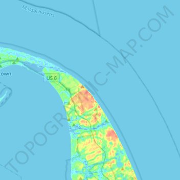
Name: Truro topographic map, elevation, terrain.
Location: Truro, Barnstable County, Massachusetts, United States (41.94320 -70.19025 42.12681 -69.93474)
Average elevation: 10 ft
Minimum elevation: -26 ft
Maximum elevation: 167 ft
Barnstable County trails, hiking, mountain biking, running and outdoor activities
Other topographic maps
Click on a map to view its topography, its elevation and its terrain.
Opeechee Heights Beach
United States > Massachusetts > Barnstable County > Barnstable > Centerville
Average elevation: 46 ft
Bourne Corners
United States > Massachusetts > Barnstable County > Bourne > Buzzards Bay
Average elevation: 30 ft
Gray Gables
United States > Massachusetts > Barnstable County > Bourne > Buzzards Bay
Average elevation: 16 ft
West Barnstable
United States > Massachusetts > Barnstable County > West Barnstable
Average elevation: 49 ft
Washburn Island
United States > Massachusetts > Barnstable County > Falmouth > Menauhant
Average elevation: 3 ft
Campground Landing
United States > Massachusetts > Barnstable County > Eastham
Average elevation: 20 ft
Barnstable
United States > Massachusetts > Barnstable County > Barnstable > Barnstable
Average elevation: 33 ft
Bournedale
United States > Massachusetts > Barnstable County > Bourne > Bournedale
Average elevation: 95 ft