Geolocate

Barton topographic map

Click on the map to display elevation.

About this map

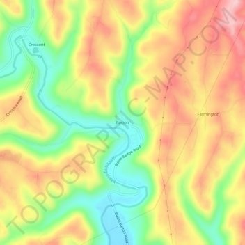
Name: Barton topographic map, elevation, terrain.

Location: Barton, Belmont County, Ohio, 43905, United States (40.08729 -80.86120 40.12729 -80.82120)

Average elevation: 1,033 ft

Minimum elevation: 738 ft

Maximum elevation: 1,309 ft

Belmont County trails, hiking, mountain biking, running and outdoor activities

Other topographic maps

Click on a map to view its topography, its elevation and its terrain.

Neffs

United States > Ohio > Belmont County > Neffs

Average elevation: 984 ft

Morristown

United States > Ohio > Belmont County

Average elevation: 1,227 ft

Flushing

United States > Ohio > Belmont County

Average elevation: 1,198 ft

Holloway

United States > Ohio > Belmont County

Average elevation: 1,027 ft

Brookside

United States > Ohio > Belmont County

Average elevation: 922 ft

Bridgeport

United States > Ohio > Belmont County

Average elevation: 801 ft

Bethesda

United States > Ohio > Belmont County

Average elevation: 1,234 ft

Belmont

United States > Ohio > Belmont County

Average elevation: 1,184 ft

Martins Ferry

United States > Ohio > Belmont County

Average elevation: 945 ft

Powhatan Point

United States > Ohio > Belmont County

Average elevation: 791 ft

Shadyside

United States > Ohio > Belmont County

Average elevation: 804 ft

Yorkville

United States > Ohio > Belmont County

Average elevation: 840 ft

Piedmont Lake

United States > Ohio > Belmont County

Average elevation: 1,053 ft

Gear up for your next adventure:

🥇GPS Hiking Watch - Multi‑sport GPS watch with navigation and trail tracking
🕶️GPS Smartphone Mount - Secure mount for phone navigation
🧯Emergency Survival Kit - All‑in‑one survival essentials for the backcountry
🔌USB Car Charger - Car charger for on‑the‑go power needs
🪵Folding Camp Saw - Compact saw for wood and campsite work

As an Amazon Associate, this site earns from qualifying purchases at no extra cost to you.