Geolocate

Stewart topographic map

Click on the map to display elevation.

About this map
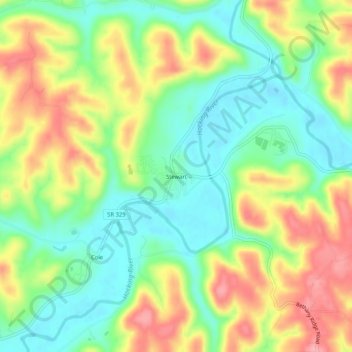
Name: Stewart topographic map, elevation, terrain.

Location: Stewart, Athens County, Ohio, 45778, United States (39.28813 -81.91458 39.32813 -81.87458)

Average elevation: 735 ft

Minimum elevation: 584 ft

Maximum elevation: 935 ft

Athens County trails, hiking, mountain biking, running and outdoor activities

Other topographic maps

Click on a map to view its topography, its elevation and its terrain.
Athens

United States > Ohio > Athens County

Average elevation: 787 ft

Pratts Fork

United States > Ohio > Athens County > Athens

Average elevation: 833 ft

Trimble

United States > Ohio > Athens County

Average elevation: 778 ft

Buchtel

United States > Ohio > Athens County

Average elevation: 781 ft

Chauncey

United States > Ohio > Athens County

Average elevation: 715 ft

Jacksonville

United States > Ohio > Athens County

Average elevation: 768 ft

Canaan Township

United States > Ohio > Athens County

Average elevation: 814 ft

Coolville

United States > Ohio > Athens County

Average elevation: 696 ft

Amesville

United States > Ohio > Athens County

Amesville is situated in the foothills of the Appalachian Mountains, approximately 45 miles south by southeast of the terminal moraine, a topographical feature often associated with the boundaries of glaciers, and is surrounded by wooded hills, narrow valleys, and numerous creeks flanked by lowland pastures…

Average elevation: 732 ft
Albany

United States > Ohio > Athens County

Average elevation: 771 ft

Gear up for your next adventure:

🧭Pro Hiking Compasses - High-accuracy liquid-filled compasses for topographic orientation
🥘Titanium Cookware - Durable, featherlight pots and pans for backpacking
🛡️Insect Repellent - Protection against bugs during outdoor activities
🛏️Cold Weather Sleeping Bag - Warm sleeping bag for cold conditions
🪄Magnetic Compass - Accurate compass for navigation

As an Amazon Associate, this site earns from qualifying purchases at no extra cost to you.