Geolocate

Trimble topographic map

Click on the map to display elevation.

About this map

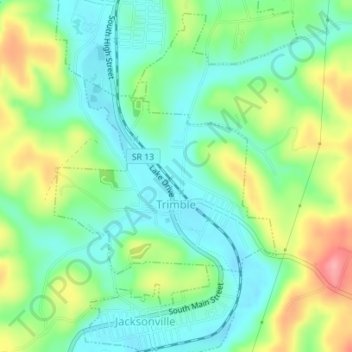
Name: Trimble topographic map, elevation, terrain.

Location: Trimble, Athens County, Ohio, 45782, United States (39.47943 -82.09115 39.49444 -82.06906)

Average elevation: 778 ft

Minimum elevation: 659 ft

Maximum elevation: 994 ft

Athens County trails, hiking, mountain biking, running and outdoor activities

Other topographic maps

Click on a map to view its topography, its elevation and its terrain.

Brookville

United States > Ohio > Athens County

Average elevation: 774 ft

Utley

United States > Ohio > Athens County

Average elevation: 814 ft

Torch

United States > Ohio > Athens County

Average elevation: 741 ft

Sharpsburg

United States > Ohio > Athens County

Average elevation: 807 ft

Shade

United States > Ohio > Athens County

Average elevation: 846 ft

Redtown

United States > Ohio > Athens County

Average elevation: 784 ft

Hamley Run

United States > Ohio > Athens County

Average elevation: 768 ft

Hartleyville

United States > Ohio > Athens County

Average elevation: 837 ft

Hebardville

United States > Ohio > Athens County

Average elevation: 755 ft

Lottridge

United States > Ohio > Athens County

Average elevation: 804 ft

Luhrig

United States > Ohio > Athens County > Athens

Average elevation: 794 ft

Mineral

United States > Ohio > Athens County

Average elevation: 843 ft

Modoc

United States > Ohio > Athens County

Average elevation: 863 ft

New England

United States > Ohio > Athens County

Average elevation: 814 ft

New Floodwood

United States > Ohio > Athens County

Average elevation: 771 ft

Pleasanton

United States > Ohio > Athens County > Athens

Average elevation: 876 ft

Guysville

United States > Ohio > Athens County

Average elevation: 732 ft

Glen Ebon

United States > Ohio > Athens County

Average elevation: 778 ft

Garden

United States > Ohio > Athens County

Average elevation: 801 ft

Beebe

United States > Ohio > Athens County

Average elevation: 764 ft

Bessemer

United States > Ohio > Athens County

Average elevation: 784 ft

Big Run

United States > Ohio > Athens County

Average elevation: 778 ft

Burr Oak

United States > Ohio > Athens County

Average elevation: 833 ft

Canaanville

United States > Ohio > Athens County

Average elevation: 755 ft

Carbondale

United States > Ohio > Athens County

Average elevation: 899 ft

Doanville

United States > Ohio > Athens County

Average elevation: 774 ft

Frost

United States > Ohio > Athens County

Average elevation: 781 ft

Beaumont

United States > Ohio > Athens County > Athens

Average elevation: 738 ft

Hockingport

United States > Ohio > Athens County

Average elevation: 689 ft

Millfield

United States > Ohio > Athens County

Average elevation: 778 ft

New Marshfield

United States > Ohio > Athens County

Average elevation: 843 ft

Stewart

United States > Ohio > Athens County

Average elevation: 735 ft

The Plains

United States > Ohio > Athens County

Average elevation: 768 ft

Gear up for your next adventure:

📡Handheld GPS Device - Reliable handheld GPS for outdoor navigation
🪶Trail Camera - Capture wildlife on your hikes
🖼️Topo Map Wall Art - Decorative topographic prints of famous peaks and regions
🔥Fast-Boil Camping Stoves - Efficient cooking systems for quick trail meals
🔭Compact Binoculars - HD vision for scouting terrain and identifying distant landmarks

As an Amazon Associate, this site earns from qualifying purchases at no extra cost to you.