
Make a donation
Gear up for your next adventure:
As an Amazon Associate, this site earns from qualifying purchases at no extra cost to you.
Münstertal topographic map
Click on the map to display elevation.
Make a donation
Gear up for your next adventure:
As an Amazon Associate, this site earns from qualifying purchases at no extra cost to you.
Münstertal
The Münstertal stretches from Staufen im Breisgau up into the Black Forest. It divides into several side valleys and extends in the direction of Belchen(Schwarzwald), via the district of Stohren towards the Schauinsland and via the Münsterhalde towards Badenweiler. The altitude of the Münstertal ranges from 380 m above sea level up to 1414 m on the summit of the Belchen, which represents a difference of 1060 meters.
Make a donation
Gear up for your next adventure:
As an Amazon Associate, this site earns from qualifying purchases at no extra cost to you.
About this map
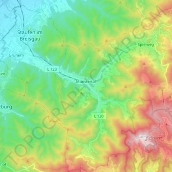
Name: Münstertal topographic map, elevation, terrain.
Average elevation: 2,110 ft
Minimum elevation: 804 ft
Maximum elevation: 4,616 ft
Make a donation
Gear up for your next adventure:
As an Amazon Associate, this site earns from qualifying purchases at no extra cost to you.
Other topographic maps
Click on a map to view its topography, its elevation and its terrain.
Dietenbach
Germany > Baden-Württemberg > Landkreis Breisgau-Hochschwarzwald > Kirchzarten (Kernort) > Kirchzarten
Average elevation: 1,581 ft
Kaiserstuhl
Germany > Baden-Württemberg > Landkreis Breisgau-Hochschwarzwald
Average elevation: 810 ft
Rheintal
Germany > Baden-Württemberg > Landkreis Breisgau-Hochschwarzwald > Müllheim im Markgräflerland
Average elevation: 1,391 ft
Make a donation
Gear up for your next adventure:
As an Amazon Associate, this site earns from qualifying purchases at no extra cost to you.
Wolfenweiler
Germany > Baden-Württemberg > Landkreis Breisgau-Hochschwarzwald
Average elevation: 856 ft