
Make a donation
Gear up for your next adventure:
As an Amazon Associate, this site earns from qualifying purchases at no extra cost to you.
Kaiserstuhl topographic map
Click on the map to display elevation.
Make a donation
Gear up for your next adventure:
As an Amazon Associate, this site earns from qualifying purchases at no extra cost to you.
About this map
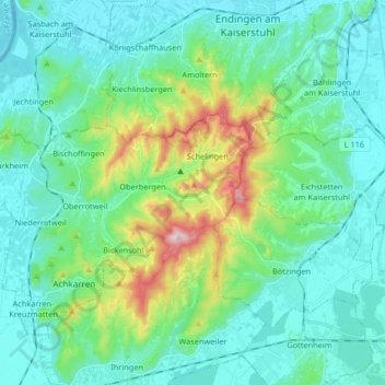
Name: Kaiserstuhl topographic map, elevation, terrain.
Average elevation: 810 ft
Minimum elevation: 561 ft
Maximum elevation: 1,778 ft
Make a donation
Gear up for your next adventure:
As an Amazon Associate, this site earns from qualifying purchases at no extra cost to you.
Other topographic maps
Click on a map to view its topography, its elevation and its terrain.
Schluchsee
Germany > Baden-Württemberg > Landkreis Breisgau-Hochschwarzwald
Average elevation: 3,261 ft
Bubenbach
Germany > Baden-Württemberg > Landkreis Breisgau-Hochschwarzwald
It lies at an altitude between 800 and 1130m above sea level in the Breg valley.
Average elevation: 3,241 ft
79853
Germany > Baden-Württemberg > Landkreis Breisgau-Hochschwarzwald > Lenzkirch (Kernort)
Average elevation: 2,936 ft
Make a donation
Gear up for your next adventure:
As an Amazon Associate, this site earns from qualifying purchases at no extra cost to you.
Neustadt im Schwarzwald
Germany > Baden-Württemberg > Landkreis Breisgau-Hochschwarzwald
Average elevation: 3,094 ft
Unadingen
Germany > Baden-Württemberg > Landkreis Breisgau-Hochschwarzwald > Löffingen
Average elevation: 2,503 ft
Hartheim am Rhein
Germany > Baden-Württemberg > Landkreis Breisgau-Hochschwarzwald
Average elevation: 676 ft
Hinterzarten
Germany > Baden-Württemberg > Landkreis Breisgau-Hochschwarzwald
Average elevation: 3,238 ft
Make a donation
Gear up for your next adventure:
As an Amazon Associate, this site earns from qualifying purchases at no extra cost to you.
79424
Germany > Baden-Württemberg > Landkreis Breisgau-Hochschwarzwald > Auggen
Average elevation: 853 ft
Horben
Germany > Baden-Württemberg > Landkreis Breisgau-Hochschwarzwald
Horben is located to the south of the city of Freiburg and east of the Hexental valley on the western slope of the Schauinsland mountain range. It lies between the mountains of "Illenberg" (642 m [2,106 ft]) and "Eduardshöhe" (859 m [2,818 ft]). The area is the source of the Bohrer and Selzenbach creeks.…
Average elevation: 2,162 ft
Altglashütten
Germany > Baden-Württemberg > Landkreis Breisgau-Hochschwarzwald
Feldberg is a municipality in the district of Breisgau-Hochschwarzwald in Baden-Württemberg in southern Germany. It is located near the Feldberg, the highest summit in Baden-Württemberg. It comprises the settlements of Altglashütten, Neuglashütten, Falkau, Bärental, and Feldberg. At an elevation of 1,277…
Average elevation: 3,369 ft
Raitenbuch
Germany > Baden-Württemberg > Landkreis Breisgau-Hochschwarzwald > Lenzkirch
Average elevation: 3,268 ft
Make a donation
Gear up for your next adventure:
As an Amazon Associate, this site earns from qualifying purchases at no extra cost to you.
Rötenbach
Germany > Baden-Württemberg > Landkreis Breisgau-Hochschwarzwald
Average elevation: 2,841 ft
Breisach (Kernstadt)
Germany > Baden-Württemberg > Landkreis Breisgau-Hochschwarzwald > Breisach am Rhein > Hochstetten
Average elevation: 696 ft
Dietenbach
Germany > Baden-Württemberg > Landkreis Breisgau-Hochschwarzwald > Kirchzarten (Kernort) > Kirchzarten
Average elevation: 1,581 ft
Make a donation
Gear up for your next adventure:
As an Amazon Associate, this site earns from qualifying purchases at no extra cost to you.
Merzhausen
Germany > Baden-Württemberg > Landkreis Breisgau-Hochschwarzwald
Average elevation: 1,129 ft
St. Märgen
Germany > Baden-Württemberg > Landkreis Breisgau-Hochschwarzwald
Average elevation: 2,789 ft
Oberbränd
Germany > Baden-Württemberg > Landkreis Breisgau-Hochschwarzwald
Average elevation: 3,186 ft
Burkheim
Germany > Baden-Württemberg > Landkreis Breisgau-Hochschwarzwald > Burkheim
Average elevation: 659 ft
Make a donation
Gear up for your next adventure:
As an Amazon Associate, this site earns from qualifying purchases at no extra cost to you.
St. Peter
Germany > Baden-Württemberg > Landkreis Breisgau-Hochschwarzwald
Average elevation: 2,635 ft
Titisee-Neustadt
Germany > Baden-Württemberg > Landkreis Breisgau-Hochschwarzwald
Average elevation: 3,189 ft
Horben
Germany > Baden-Württemberg > Landkreis Breisgau-Hochschwarzwald
Horben is located to the south of the city of Freiburg and east of the Hexental valley on the western slope of the Schauinsland mountain range. It lies between the mountains of "Illenberg" (642 m [2,106 ft]) and "Eduardshöhe" (859 m [2,818 ft]). The area is the source of the Bohrer and Selzenbach creeks.…
Average elevation: 2,162 ft
Make a donation
Gear up for your next adventure:
As an Amazon Associate, this site earns from qualifying purchases at no extra cost to you.
Rheintal
Germany > Baden-Württemberg > Landkreis Breisgau-Hochschwarzwald > Müllheim im Markgräflerland
Average elevation: 1,391 ft
Lenzkirch
Germany > Baden-Württemberg > Landkreis Breisgau-Hochschwarzwald
Saig is a health resort on the southern flank of the Hochfirst, and at about 1,000m elevation is the highest community in the municipality. It has about 1,200 beds available for tourists.
Average elevation: 3,100 ft
Feldberg
Germany > Baden-Württemberg > Landkreis Breisgau-Hochschwarzwald
Feldberg is a municipality in the district of Breisgau-Hochschwarzwald in Baden-Württemberg in southern Germany. It is located near the Feldberg, the highest summit in Baden-Württemberg. It comprises the settlements of Altglashütten, Neuglashütten, Falkau, Bärental, and Feldberg. At an elevation of 1,277…
Average elevation: 3,402 ft
Make a donation
Gear up for your next adventure:
As an Amazon Associate, this site earns from qualifying purchases at no extra cost to you.
Gundelfingen
Germany > Baden-Württemberg > Landkreis Breisgau-Hochschwarzwald > Gundelfingen
Average elevation: 961 ft
Schallstadt
Germany > Baden-Württemberg > Landkreis Breisgau-Hochschwarzwald
Average elevation: 873 ft
Wolfenweiler
Germany > Baden-Württemberg > Landkreis Breisgau-Hochschwarzwald
Average elevation: 856 ft
Make a donation
Gear up for your next adventure:
As an Amazon Associate, this site earns from qualifying purchases at no extra cost to you.
Münstertal
Germany > Baden-Württemberg > Landkreis Breisgau-Hochschwarzwald
The Münstertal stretches from Staufen im Breisgau up into the Black Forest. It divides into several side valleys and extends in the direction of Belchen(Schwarzwald), via the district of Stohren towards the Schauinsland and via the Münsterhalde towards Badenweiler. The altitude of the Münstertal ranges from…
Average elevation: 2,110 ft
Badenweiler
Germany > Baden-Württemberg > Landkreis Breisgau-Hochschwarzwald
Average elevation: 1,781 ft
Grunern
Germany > Baden-Württemberg > Landkreis Breisgau-Hochschwarzwald > Staufen im Breisgau
Average elevation: 1,332 ft