Geolocate

Byrnihat topographic map

Click on the map to display elevation.

About this map

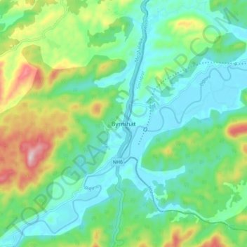
Name: Byrnihat topographic map, elevation, terrain.

Location: Byrnihat, Umling, Ri-Bhoi, Meghalaya, 782423, India (26.01433 91.82965 26.09433 91.90965)

Average elevation: 561 ft

Minimum elevation: 184 ft

Maximum elevation: 1,552 ft

Other topographic maps

Click on a map to view its topography, its elevation and its terrain.

Umling

India > Meghalaya > Umling

Average elevation: 1,549 ft

Gear up for your next adventure:

🔥Camping Stove - Portable stove for camping and backcountry cooking
🥾Hiking Shoes - Durable and comfortable shoes for trail hiking
🛰️Satellite Messengers - Emergency SOS and two-way messaging for off-grid adventures
📡GPS Antenna Upgrade - Enhance GPS reception in remote terrain
📖Nature Tracking Books - Learn to track wildlife and terrain

As an Amazon Associate, this site earns from qualifying purchases at no extra cost to you.