
Zvimba topographic map
Click on the map to display elevation.
About this map
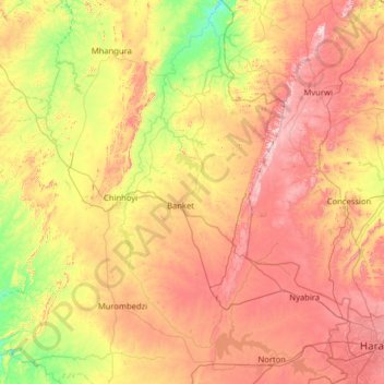
Name: Zvimba topographic map, elevation, terrain.
Location: Zvimba, Mashonaland West Province, Zimbabwe (-17.95157 29.83604 -16.73436 30.95849)
Average elevation: 4,101 ft
Minimum elevation: 2,946 ft
Maximum elevation: 5,728 ft
Other topographic maps
Click on a map to view its topography, its elevation and its terrain.
Kariba
Zimbabwe > Mashonaland West Province > Kariba
Kariba has a tropical savanna climate (Köppen climate classification Aw), with warm winters and very hot summers, and a marked drier season in the winter. Although it is relatively cooler than typical tropical places in the winter and does get occasional 5 °C (41 °F) lows, Kariba nevertheless meets the…
Average elevation: 1,804 ft