
Olde Georgetowne topographic map
Click on the map to display elevation.
About this map
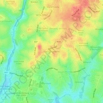
Name: Olde Georgetowne topographic map, elevation, terrain.
Average elevation: 636 ft
Minimum elevation: 545 ft
Maximum elevation: 732 ft
Mecklenburg County trails, hiking, mountain biking, running and outdoor activities
Other topographic maps
Click on a map to view its topography, its elevation and its terrain.
Coulwood Park
United States > North Carolina > Mecklenburg County > Charlotte > Coulwood Hills
Average elevation: 692 ft
Idlewild Farms
United States > North Carolina > Mecklenburg County > Charlotte
Average elevation: 728 ft
Carmel Road Park
United States > North Carolina > Mecklenburg County > Charlotte > Carmel Woods
Average elevation: 650 ft
Mecklenberg Wildlife Club Lake
United States > North Carolina > Mecklenburg County > Charlotte
Average elevation: 702 ft
Beverly Woods East
United States > North Carolina > Mecklenburg County > Charlotte
Average elevation: 666 ft