
Oforikrom Municipal District topographic map
Interactive map
Click on the map to display elevation.
About this map
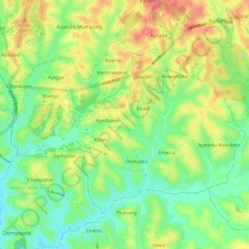
Name: Oforikrom Municipal District topographic map, elevation, terrain.
Location: Oforikrom Municipal District, Ashanti Region, Ghana (6.63781 -1.60192 6.70878 -1.50238)
Average elevation: 853 ft
Minimum elevation: 741 ft
Maximum elevation: 1,010 ft
Other topographic maps
Click on a map to view its topography, its elevation and its terrain.
Afigya-Kwabre South District
Afigya-Kwabre South District, Ashanti Region, Ghana
Average elevation: 912 ft
Ahafo-Ano South East District
Ahafo-Ano South East District, Ashanti Region, Ghana
Average elevation: 942 ft
Sekyere Central District
Ghana > Ashanti Region > Sekyere Central District
Sekyere Central District, Ashanti Region, Ghana
Average elevation: 558 ft
Kumasi
Ghana > Ashanti Region > Kumasi Metropolitan District
Kumasi, Kumasi Metropolitan District, Ashanti Region, Ghana
Average elevation: 840 ft