
Afigya-Kwabre South District topographic map
Interactive map
Click on the map to display elevation.
About this map
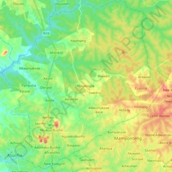
Name: Afigya-Kwabre South District topographic map, elevation, terrain.
Location: Afigya-Kwabre South District, Ashanti Region, Ghana (6.75141 -1.69707 6.92854 -1.52497)
Average elevation: 912 ft
Minimum elevation: 699 ft
Maximum elevation: 1,296 ft
Other topographic maps
Click on a map to view its topography, its elevation and its terrain.
Ahafo-Ano South East District
Ahafo-Ano South East District, Ashanti Region, Ghana
Average elevation: 942 ft
Oforikrom Municipal District
Oforikrom Municipal District, Ashanti Region, Ghana
Average elevation: 853 ft
Sekyere Central District
Ghana > Ashanti Region > Sekyere Central District
Sekyere Central District, Ashanti Region, Ghana
Average elevation: 558 ft
Kumasi
Ghana > Ashanti Region > Kumasi Metropolitan District
Kumasi, Kumasi Metropolitan District, Ashanti Region, Ghana
Average elevation: 840 ft