Geolocate

Beulah topographic map

Click on the map to display elevation.

About this map

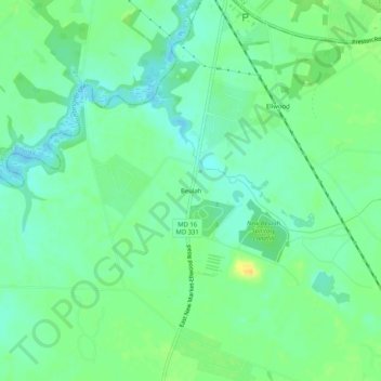
Name: Beulah topographic map, elevation, terrain.

Location: Beulah, Dorchester County, Maryland, 21643, United States (38.65789 -75.91910 38.69789 -75.87910)

Average elevation: 33 ft

Minimum elevation: -3 ft

Maximum elevation: 85 ft

Dorchester County trails, hiking, mountain biking, running and outdoor activities

Other topographic maps

Click on a map to view its topography, its elevation and its terrain.

Vienna

United States > Maryland > Dorchester County

Average elevation: 10 ft

Gear up for your next adventure:

🥩Freeze-Dried Meals - Nutritious and lightweight food for remote expeditions
👟Trail Running Shoes - Lightweight shoes for trail runners
🧥Men's Rain Shells - Premium waterproof and breathable jackets for mountain weather
🎒Gear Packing Cubes - Organize your backpack efficiently
🥄Camping Utensil Set - Lightweight utensils for outdoor meals

As an Amazon Associate, this site earns from qualifying purchases at no extra cost to you.