Geolocate

Siridao topographic map

Click on the map to display elevation.

About this map

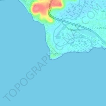
Name: Siridao topographic map, elevation, terrain.

Location: Siridao, Tiswadi, North Goa District, Goa, 403203, India (15.41146 73.84350 15.45146 73.88350)

Average elevation: 13 ft

Minimum elevation: -3 ft

Maximum elevation: 230 ft

Other topographic maps

Click on a map to view its topography, its elevation and its terrain.

Divar Island

India > Goa > Tiswadi > Naroa

Average elevation: 36 ft

Miramar Beach

India > Goa > Tiswadi > Panaji

Average elevation: 10 ft

Mala Lake

India > Goa > Tiswadi > Panaji

Average elevation: 33 ft

Divar Island

India > Goa > Tiswadi > Piedade

Average elevation: 36 ft

Chorão Island

India > Goa > Tiswadi > Chorao

Average elevation: 43 ft

Gear up for your next adventure:

🌎3D Topographic Globes - Raised relief globes for a tactile understanding of geography
Backpacking Tent - Lightweight and durable tent for multi‑day hikes
🥾Men's Hiking Boots - Durable, waterproof footwear for rugged terrain and steep inclines
📌Outdoor GPS Map App - Apps and devices for digital topographic navigation
🦶Carbon Trekking Poles - Reduce knee impact on steep descents with ultra-light poles

As an Amazon Associate, this site earns from qualifying purchases at no extra cost to you.