
Make a donation
Gear up for your next adventure:
As an Amazon Associate, this site earns from qualifying purchases at no extra cost to you.
Blooming Valley topographic map
Click on the map to display elevation.
Make a donation
Gear up for your next adventure:
As an Amazon Associate, this site earns from qualifying purchases at no extra cost to you.
Blooming Valley
The Borough of Blooming Valley lies on the divide between Blooming Valley Run and Sugar Creek, whose waters eventually flow to French Creek. The two streams are separated by a swampy area. The elevation of the borough ranges from 1,219 ft (372 m) at Blooming Valley Run to 1,530 ft (470 m) near the eastern boundary.
Make a donation
Gear up for your next adventure:
As an Amazon Associate, this site earns from qualifying purchases at no extra cost to you.
About this map
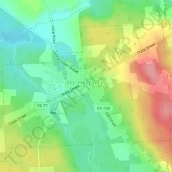
Name: Blooming Valley topographic map, elevation, terrain.
Average elevation: 1,322 ft
Minimum elevation: 1,184 ft
Maximum elevation: 1,516 ft
Crawford County trails, hiking, mountain biking, running and outdoor activities
Make a donation
Gear up for your next adventure:
As an Amazon Associate, this site earns from qualifying purchases at no extra cost to you.
Other topographic maps
Click on a map to view its topography, its elevation and its terrain.
Espyville
United States > Pennsylvania > Crawford County > Pymatuning Central
Average elevation: 1,047 ft