
Make a donation
Gear up for your next adventure:
As an Amazon Associate, this site earns from qualifying purchases at no extra cost to you.
Black Ash topographic map
Click on the map to display elevation.
Make a donation
Gear up for your next adventure:
As an Amazon Associate, this site earns from qualifying purchases at no extra cost to you.
About this map
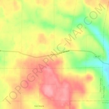
Name: Black Ash topographic map, elevation, terrain.
Average elevation: 1,529 ft
Minimum elevation: 1,319 ft
Maximum elevation: 1,670 ft
Crawford County trails, hiking, mountain biking, running and outdoor activities
Make a donation
Gear up for your next adventure:
As an Amazon Associate, this site earns from qualifying purchases at no extra cost to you.
Other topographic maps
Click on a map to view its topography, its elevation and its terrain.
Hydetown
United States > Pennsylvania > Crawford County
Hydetown Borough is located just south of the southern terminal moraine for glaciation in northwestern Pennsylvania. The borough is drained by Oil Creek, a southward-flowing tributary of the Allegheny River, which runs through the northwestern and southwestern sides of the borough and Thompson Creek, which…
Average elevation: 1,352 ft
Blooming Valley
United States > Pennsylvania > Crawford County
The Borough of Blooming Valley lies on the divide between Blooming Valley Run and Sugar Creek, whose waters eventually flow to French Creek. The two streams are separated by a swampy area. The elevation of the borough ranges from 1,219 ft (372 m) at Blooming Valley Run to 1,530 ft (470 m) near the eastern…
Average elevation: 1,322 ft
Make a donation
Gear up for your next adventure:
As an Amazon Associate, this site earns from qualifying purchases at no extra cost to you.
Erie National Wildlife Refuge
United States > Pennsylvania > Crawford County
Average elevation: 1,414 ft
Centerville
United States > Pennsylvania > Crawford County
Centerville Borough is located just north of the southern terminal moraine for glaciation in northwestern Pennsylvania. The borough is drained by Oil Creek, a southward-flowing tributary of the Allegheny River, which runs through the western side of town and East Branch Oil Creek, which enters the borough from…
Average elevation: 1,342 ft
Make a donation
Gear up for your next adventure:
As an Amazon Associate, this site earns from qualifying purchases at no extra cost to you.
Make a donation
Gear up for your next adventure:
As an Amazon Associate, this site earns from qualifying purchases at no extra cost to you.
Make a donation
Gear up for your next adventure:
As an Amazon Associate, this site earns from qualifying purchases at no extra cost to you.