Geolocate

Great Falls topographic map

Click on the map to display elevation.

About this map

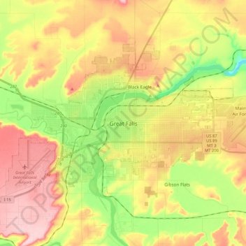
Name: Great Falls topographic map, elevation, terrain.

Location: Great Falls, Cascade County, Montana, United States (47.45799 -111.40747 47.55196 -111.19881)

Average elevation: 3,445 ft

Minimum elevation: 3,123 ft

Maximum elevation: 3,753 ft

Cascade County trails, hiking, mountain biking, running and outdoor activities

Other topographic maps

Click on a map to view its topography, its elevation and its terrain.

Stockett

United States > Montana > Cascade County

Average elevation: 3,816 ft

Great Falls

United States > Montana > Cascade County > Great Falls

Average elevation: 3,520 ft

Roe River

United States > Montana > Cascade County

Average elevation: 3,360 ft

Gear up for your next adventure:

🪶Thermal Camp Blanket - Extra warmth for cold nights
🔦LED Headlamp - Bright and durable LED headlamp for night navigation
🔦Powerful Headlamps - Ultra-bright hands-free lighting for night navigation
🥤Water Filter Bottle - All‑in‑one filter bottle for safe hydration
🛰️Handheld GPS Units - Professional satellite navigators for precise backcountry mapping

As an Amazon Associate, this site earns from qualifying purchases at no extra cost to you.