Geolocate

Stockett topographic map

Click on the map to display elevation.

About this map

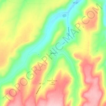
Name: Stockett topographic map, elevation, terrain.

Location: Stockett, Cascade County, Montana, 59480, United States (47.33555 -111.18674 47.37555 -111.14674)

Average elevation: 3,816 ft

Minimum elevation: 3,514 ft

Maximum elevation: 4,091 ft

Cascade County trails, hiking, mountain biking, running and outdoor activities

Other topographic maps

Click on a map to view its topography, its elevation and its terrain.

Great Falls

United States > Montana > Cascade County

Average elevation: 3,445 ft

Vaughn

United States > Montana > Cascade County

Average elevation: 3,392 ft

Ulm

United States > Montana > Cascade County

Average elevation: 3,432 ft

Great Falls

United States > Montana > Cascade County

Average elevation: 3,445 ft

Black Eagle

United States > Montana > Cascade County

Average elevation: 3,432 ft

Roe River

United States > Montana > Cascade County

Average elevation: 3,360 ft

Gear up for your next adventure:

🚑Emergency Bivvies - Heat-reflective sleeping bags for survival situations
📡GPS Antenna Upgrade - Enhance GPS reception in remote terrain
🌄Hiking Binoculars - Compact binoculars for scenic views and trail spotting
📡Handheld GPS Device - Reliable handheld GPS for outdoor navigation
🥩Freeze-Dried Meals - Nutritious and lightweight food for remote expeditions

As an Amazon Associate, this site earns from qualifying purchases at no extra cost to you.