
Mountain View topographic map
Click on the map to display elevation.
About this map
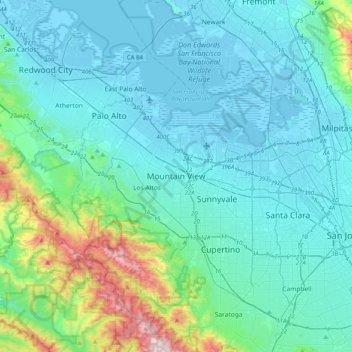
Name: Mountain View topographic map, elevation, terrain.
Average elevation: 443 ft
Minimum elevation: -23 ft
Maximum elevation: 3,110 ft
Other topographic maps
Click on a map to view its topography, its elevation and its terrain.
San Jose
United States > California > Santa Clara County
San Jose, located in Santa Clara County, California, features a diverse topography characterized by a mix of low-lying plains and rolling hills. The city sits at an average elevation of approximately 82 feet (25 meters) above sea level, with the surrounding terrain including the foothills of the Santa Cruz…
Average elevation: 869 ft
Santa Cruz Mountains
United States > California > Santa Clara County
The Santa Cruz Mountains are a region of great biological diversity, encompassing cool, moist coastal ecosystems as well as warm, dry chaparral. Much of the area in the Santa Cruz mountains is considered temperate rainforest. In valleys and moist ocean-facing slopes some of the southernmost coast redwoods…
Average elevation: 755 ft
Morgan Hill
United States > California > Santa Clara County
Morgan Hill is approximately 24 mi (39 km) south of downtown San Jose, 13 mi (21 km) north of Gilroy, and 15 mi (24 km) inland from the Pacific coast. Lying in a roughly 4-mile-wide (6 km) southern extension of the Santa Clara Valley, it is bounded by the Santa Cruz Mountains to the west and the Diablo Range…
Average elevation: 502 ft
Sunnyvale
United States > California > Santa Clara County
According to the United States Census Bureau, the city has a total area of 22.7 sq mi (58.8 km2), of which, 22.0 sq mi (56.9 km2) of it is land and 0.69 sq mi (1.8 km2) of it (3.09%) is water. Its elevation is 130 feet above sea level.
Average elevation: 79 ft
Santa Clara
United States > California > Santa Clara County
In 1905, the first public high-altitude flights by humans were made over Santa Clara in gliders designed by John J. Montgomery. The semiconductor industry, which sprouted around 1960, changed the city and surrounding Valley of Heart's Delight; little of its agricultural past remains.
Average elevation: 59 ft
Palo Alto
United States > California > Santa Clara County
The official elevation is 30 feet (9 m) above sea level, but the city boundaries reach well into the northern section of the Santa Cruz Mountains.
Average elevation: 614 ft
Palo Alto
United States > California > Santa Clara County
The official elevation is 30 feet (9 m) above sea level, but the city boundaries reach well into the peninsula hills.
Average elevation: 614 ft
Milpitas
United States > California > Santa Clara County
The median elevation of Milpitas is 19 feet (6 m). At Piedmont Road, Evans Road, and North Park Victoria Avenue, the elevation is generally about 100 feet (30 m), while the western area is almost at sea level. The highest point in Milpitas is a 1,289-foot (393 m) peak in the southeastern foothills.
Average elevation: 151 ft
Ed R. Levin County Park
United States > California > Santa Clara County > Milpitas
Average elevation: 988 ft
Gilroy
United States > California > Santa Clara County
Gilroy is approximately 16 miles (26 km) south of San Jose, California (Bailey Avenue (37.206770, -121.729150) to Monterey/Day Road (37.038210, -121.584480)) on U.S. Route 101 and 19 miles (31 km) inland from the Pacific Coast. Despite its apparent close proximity to San Jose, it is important to note that…
Average elevation: 351 ft
Lexington Hills
United States > California > Santa Clara County > Redwood Estates
Average elevation: 1,391 ft
Vasona Lake County Park
United States > California > Santa Clara County > Los Gatos > Shannon
Average elevation: 358 ft
Lexington Reservoir County Park
United States > California > Santa Clara County > Los Gatos
The reservoir is in the foothills of the Santa Cruz Mountains, at an elevation of 645 feet (197 m).
Average elevation: 1,083 ft
Calero 72-003 Dam
United States > California > Santa Clara County > San Jose
Average elevation: 614 ft
Upper Los Gatos Creek Watershed Reserve
United States > California > Santa Clara County > Saratoga
Average elevation: 1,309 ft
Sunnyvale
United States > California > Santa Clara County
According to the United States Census Bureau, the city has a total area of 22.7 sq mi (58.8 km2), of which, 22.0 sq mi (56.9 km2) of it is land and 0.69 sq mi (1.8 km2) of it (3.09%) is water. Its elevation is 130 feet above sea level.
Average elevation: 79 ft
Palo Alto
United States > California > Santa Clara County
The official elevation is 30 feet (9 m) above sea level, but the city boundaries reach well into the peninsula hills.
Average elevation: 614 ft
Santa Clara
United States > California > Santa Clara County
In 1905, the first public high-altitude flights by humans were made over Santa Clara in gliders designed by John J. Montgomery. The semiconductor industry, which sprouted around 1960, changed the city and surrounding Valley of Heart's Delight; little of its agricultural past remains.
Average elevation: 59 ft
Santa Cruz Mountains
United States > California > Santa Clara County
The Santa Cruz Mountains are a region of great biological diversity, encompassing cool, moist coastal ecosystems as well as warm, dry chaparral. Much of the area in the Santa Cruz mountains is temperate rainforest. In valleys and moist ocean-facing slopes some of the southernmost coast redwoods grow, along…
Average elevation: 755 ft
Morgan Hill
United States > California > Santa Clara County
Morgan Hill is approximately 24 mi (39 km) south of downtown San Jose, 13 mi (21 km) north of Gilroy, and 15 mi (24 km) inland from the Pacific coast. Lying in a roughly 4-mile-wide (6 km) southern extension of the Santa Clara Valley, it is bounded by the Santa Cruz Mountains to the west and the Diablo Range…
Average elevation: 502 ft
Santa Clara
United States > California > Santa Clara County
In 1905, the first public high-altitude flights by humans were made over Santa Clara in gliders designed by John J. Montgomery. The semiconductor industry, which sprouted around 1960, changed the city and surrounding Valley of Heart's Delight; little of its agricultural past remains.
Average elevation: 59 ft
Joseph D. Grant County Park
United States > California > Santa Clara County
Average elevation: 2,067 ft
Santa Clara
United States > California > Santa Clara County
In 1905, the first public high-altitude flights by humans were made over Santa Clara in gliders designed by John J. Montgomery. The semiconductor industry, which sprouted around 1960, changed the city and surrounding Valley of Heart's Delight; little of its agricultural past remains.
Average elevation: 59 ft
Palo Alto
United States > California > Santa Clara County
The official elevation is 30 feet (9 m) above sea level, but the city boundaries reach well into the northern section of the Santa Cruz Mountains.
Average elevation: 614 ft
Gilroy
United States > California > Santa Clara County
Due to the moderating influence of the Pacific Ocean, Gilroy experiences a warm Mediterranean climate (Köppen Csb, bordering on Csa). Temperatures range from an average midsummer maximum of 90.1 °F (32.3 °C) to an average midwinter low of 33.6 °F (0.9 °C). Average annual precipitation is 18.9 inches (480…
Average elevation: 351 ft
Palo Alto
United States > California > Santa Clara County
The official elevation is 30 feet (9 m) above sea level, but the city boundaries reach well into the northern section of the Santa Cruz Mountains.
Average elevation: 614 ft
Gilroy
United States > California > Santa Clara County
Gilroy is approximately 16 miles (26 km) south of San Jose, California (Bailey Avenue (37.206770, -121.729150) to Monterey/Day Road (37.038210, -121.584480)) on U.S. Route 101 and 19 miles (31 km) inland from the Pacific Coast. Despite its apparent close proximity to San Jose, it is important to note that…
Average elevation: 351 ft
Palo Alto
United States > California > Santa Clara County
The official elevation is 30 feet (9 m) above sea level, but the city boundaries reach well into the peninsula hills.
Average elevation: 614 ft