Geolocate

Mandisha topographic map

Click on the map to display elevation.

About this map

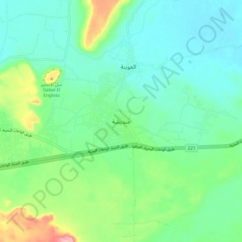
Name: Mandisha topographic map, elevation, terrain.

Location: Mandisha, Giza, Egypt (28.31130 28.89335 28.39130 28.97335)

Average elevation: 413 ft

Minimum elevation: 276 ft

Maximum elevation: 814 ft

Other topographic maps

Click on a map to view its topography, its elevation and its terrain.

6th of October city

Egypt > Giza

Average elevation: 453 ft

El Hassana Dome Protectorate

Egypt > Giza > Sheikh Zayed

Average elevation: 354 ft

Waraq Al Arab City

Egypt > Giza

Average elevation: 69 ft

مدينة الشيخ زايد

Egypt > Giza

Average elevation: 400 ft

Wadi Al-Hitan (Whale Valley)

Egypt > Giza

Average elevation: 404 ft

Nazlet Al Siman and Al Sisi

Egypt > Giza

Average elevation: 138 ft

Al Badrashin City

Egypt > Giza

Average elevation: 72 ft

Gear up for your next adventure:

📡GPS Antenna Upgrade - Enhance GPS reception in remote terrain
🏔️Mountain Trail Maps - High‑detail maps for popular peaks
🎒Gear Packing Cubes - Organize your backpack efficiently
🪶Compact Camp Shovel - Folding shovel for campsite tasks
🌡️Handheld Weather Meters - Measure wind, temp, and pressure for safe mountain travel

As an Amazon Associate, this site earns from qualifying purchases at no extra cost to you.