
Nazlet Al Siman and Al Sisi topographic map
Interactive map
Click on the map to display elevation.
About this map
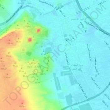
Name: Nazlet Al Siman and Al Sisi topographic map, elevation, terrain.
Location: Nazlet Al Siman and Al Sisi, Giza, Egypt (29.95153 31.13264 29.98985 31.15742)
Average elevation: 138 ft
Minimum elevation: 49 ft
Maximum elevation: 413 ft
Other topographic maps
Click on a map to view its topography, its elevation and its terrain.
Black Desert
Egypt > Giza > Northern Oases
Black Desert, Al Wahat Al Bahareya, Al Farafrah Road, Northern Oases, Giza, Egypt
Average elevation: 617 ft
Wadi Al-Hitan (Whale Valley)
Wadi Al-Hitan (Whale Valley), Giza, Egypt
Average elevation: 404 ft
Warraq al Hadar
Egypt > Giza > Warraq al Hadar
Warraq al Hadar, Giza, 12662, Egypt
Average elevation: 69 ft