
Make a donation
Gear up for your next adventure:
As an Amazon Associate, this site earns from qualifying purchases at no extra cost to you.
Dühren topographic map
Click on the map to display elevation.
Make a donation
Gear up for your next adventure:
As an Amazon Associate, this site earns from qualifying purchases at no extra cost to you.
About this map
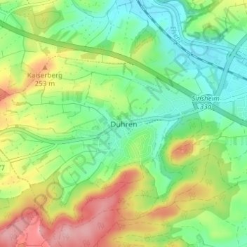
Name: Dühren topographic map, elevation, terrain.
Average elevation: 669 ft
Minimum elevation: 492 ft
Maximum elevation: 948 ft
Make a donation
Gear up for your next adventure:
As an Amazon Associate, this site earns from qualifying purchases at no extra cost to you.
Other topographic maps
Click on a map to view its topography, its elevation and its terrain.
Burg Steinsberg
Deutschland > Baden-Württemberg > Rhein-Neckar-Kreis > Sinsheim
Die Burg Steinsberg ist die zum Teil restaurierte Ruine einer mittelalterlichen Höhenburg im Ort Weiler, einem Stadtteil von Sinsheim im Rhein-Neckar-Kreis (Baden-Württemberg).
Average elevation: 807 ft
Make a donation
Gear up for your next adventure:
As an Amazon Associate, this site earns from qualifying purchases at no extra cost to you.
Waldangelloch
Deutschland > Baden-Württemberg > Rhein-Neckar-Kreis > Sinsheim
Average elevation: 751 ft