
Make a donation
Gear up for your next adventure:
As an Amazon Associate, this site earns from qualifying purchases at no extra cost to you.
Burg Steinsberg topographic map
Click on the map to display elevation.
Make a donation
Gear up for your next adventure:
As an Amazon Associate, this site earns from qualifying purchases at no extra cost to you.
Burg Steinsberg
Die Burg Steinsberg ist die zum Teil restaurierte Ruine einer mittelalterlichen Höhenburg im Ort Weiler, einem Stadtteil von Sinsheim im Rhein-Neckar-Kreis (Baden-Württemberg).
Make a donation
Gear up for your next adventure:
As an Amazon Associate, this site earns from qualifying purchases at no extra cost to you.
About this map
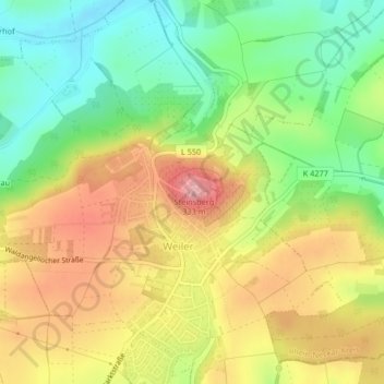
Name: Burg Steinsberg topographic map, elevation, terrain.
Average elevation: 807 ft
Minimum elevation: 564 ft
Maximum elevation: 1,079 ft
Make a donation
Gear up for your next adventure:
As an Amazon Associate, this site earns from qualifying purchases at no extra cost to you.
Other topographic maps
Click on a map to view its topography, its elevation and its terrain.
Make a donation
Gear up for your next adventure:
As an Amazon Associate, this site earns from qualifying purchases at no extra cost to you.
Waldangelloch
Deutschland > Baden-Württemberg > Rhein-Neckar-Kreis > Sinsheim
Average elevation: 751 ft
Make a donation
Gear up for your next adventure:
As an Amazon Associate, this site earns from qualifying purchases at no extra cost to you.
Hoffenheim
Deutschland > Baden-Württemberg > Rhein-Neckar-Kreis > Sinsheim
Der Ort zählte als reichsritterschaftlicher Besitz zum Ritterkanton Kraichgau. Im 13. und 14. Jahrhundert werden in Urkunden als Zeugen genannt: 1262 Hildebrandus de Hoveheim, 1310 Cunradus de Hoveheim, 1396 Diether von Hoffenheim, Edelknecht. Mit großer Wahrscheinlichkeit handelte es sich um Ortsadlige, die…
Average elevation: 650 ft