
Saltair topographic map
Click on the map to display elevation.
About this map
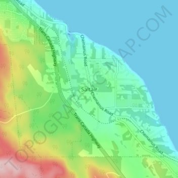
Name: Saltair topographic map, elevation, terrain.
Average elevation: 217 ft
Minimum elevation: -3 ft
Maximum elevation: 843 ft
Other topographic maps
Click on a map to view its topography, its elevation and its terrain.
Valdes Island
Canada > British Columbia > Cowichan Valley Regional District > Area G (Saltair / Gulf Islands)
Average elevation: 36 ft
Thetis Island
Canada > British Columbia > Cowichan Valley Regional District > Area G (Saltair / Gulf Islands) > Spune’luxutth
Average elevation: 52 ft
Ruxton Island
Canada > British Columbia > Cowichan Valley Regional District > Area G (Saltair / Gulf Islands)
Average elevation: 20 ft