
Make a donation
Gear up for your next adventure:
As an Amazon Associate, this site earns from qualifying purchases at no extra cost to you.
Te Hiku Community topographic map
Click on the map to display elevation.
Make a donation
Gear up for your next adventure:
As an Amazon Associate, this site earns from qualifying purchases at no extra cost to you.
About this map
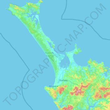
Name: Te Hiku Community topographic map, elevation, terrain.
Average elevation: 95 ft
Minimum elevation: 0 ft
Maximum elevation: 2,300 ft
Make a donation
Gear up for your next adventure:
As an Amazon Associate, this site earns from qualifying purchases at no extra cost to you.
Other topographic maps
Click on a map to view its topography, its elevation and its terrain.
Kaikohe
New Zealand > Northland > Far North District > Kaikohe-Hokianga Community
Average elevation: 709 ft
Make a donation
Gear up for your next adventure:
As an Amazon Associate, this site earns from qualifying purchases at no extra cost to you.
Ōkaihau
New Zealand > Northland > Far North District > Kaikohe-Hokianga Community
Average elevation: 679 ft
Purerua Peninsula
New Zealand > Northland > Far North District > Bay of Islands
Average elevation: 112 ft
Opononi
New Zealand > Northland > Far North District > Kaikohe-Hokianga Community
Average elevation: 167 ft
Make a donation
Gear up for your next adventure:
As an Amazon Associate, this site earns from qualifying purchases at no extra cost to you.
Lake Ōmāpere
New Zealand > Northland > Far North District > Kaikohe-Hokianga Community
Average elevation: 797 ft
Ahiaruhe Shell Bank
New Zealand > Northland > Far North District > Te Hiku Community
Average elevation: 10 ft
Make a donation
Gear up for your next adventure:
As an Amazon Associate, this site earns from qualifying purchases at no extra cost to you.
Make a donation
Gear up for your next adventure:
As an Amazon Associate, this site earns from qualifying purchases at no extra cost to you.
Rawene
New Zealand > Northland > Far North District > Kaikohe-Hokianga Community
Average elevation: 26 ft
Whirinaki River
New Zealand > Northland > Far North District > Kaikohe-Hokianga Community
Average elevation: 1,207 ft
Make a donation
Gear up for your next adventure:
As an Amazon Associate, this site earns from qualifying purchases at no extra cost to you.
Waihou River
New Zealand > Northland > Far North District > Kaikohe-Hokianga Community
Average elevation: 604 ft
Kerikeri River
New Zealand > Northland > Far North District > Bay of Islands > Waipapa
Average elevation: 236 ft
Lake Waiparera
New Zealand > Northland > Far North District > Te Hiku Community
Average elevation: 105 ft
Make a donation
Gear up for your next adventure:
As an Amazon Associate, this site earns from qualifying purchases at no extra cost to you.
Tautoro
New Zealand > Northland > Far North District > Kaikohe-Hokianga Community
Average elevation: 446 ft
Rangitoto
New Zealand > Northland > Far North District > Kaikohe-Hokianga Community
Average elevation: 79 ft
Make a donation
Gear up for your next adventure:
As an Amazon Associate, this site earns from qualifying purchases at no extra cost to you.
Paihia
New Zealand > Northland > Far North District > Bay of Islands-Whangaroa Community
Average elevation: 89 ft
Te Tii Waitangi Marae
New Zealand > Northland > Far North District > Bay of Islands-Whangaroa Community > Paihia
Average elevation: 46 ft
Onewhero Bay
New Zealand > Northland > Far North District > Bay of Islands-Whangaroa Community
Average elevation: 59 ft
Make a donation
Gear up for your next adventure:
As an Amazon Associate, this site earns from qualifying purchases at no extra cost to you.
Russell
New Zealand > Northland > Far North District > Bay of Islands-Whangaroa Community
Average elevation: 39 ft
Kerikeri
New Zealand > Northland > Far North District > Bay of Islands-Whangaroa Community
Average elevation: 249 ft
Make a donation
Gear up for your next adventure:
As an Amazon Associate, this site earns from qualifying purchases at no extra cost to you.