
Make a donation
Gear up for your next adventure:
As an Amazon Associate, this site earns from qualifying purchases at no extra cost to you.
Bellville topographic map
Click on the map to display elevation.
Make a donation
Gear up for your next adventure:
As an Amazon Associate, this site earns from qualifying purchases at no extra cost to you.
About this map
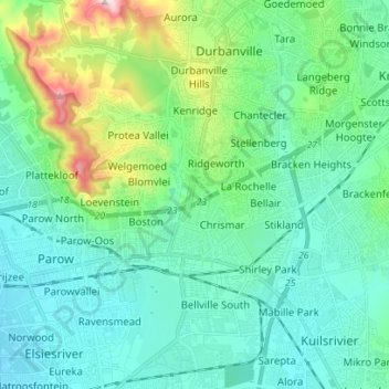
Name: Bellville topographic map, elevation, terrain.
Location: Bellville, City of Cape Town, Western Cape, South Africa (-33.94120 18.57766 -33.82513 18.67774)
Average elevation: 377 ft
Minimum elevation: 92 ft
Maximum elevation: 1,512 ft
Make a donation
Gear up for your next adventure:
As an Amazon Associate, this site earns from qualifying purchases at no extra cost to you.
Other topographic maps
Click on a map to view its topography, its elevation and its terrain.
Cape Town
South Africa > Western Cape > City of Cape Town
The Cape Peninsula is 52 km long from Mouille Point in the north to Cape Point in the south, with an area of about 470 km2, and it displays more topographical variety than other similar sized areas in southern Africa, and consequently spectacular scenery. There are diverse low-nutrient soils, large rocky…
Average elevation: 174 ft
Make a donation
Gear up for your next adventure:
As an Amazon Associate, this site earns from qualifying purchases at no extra cost to you.
Make a donation
Gear up for your next adventure:
As an Amazon Associate, this site earns from qualifying purchases at no extra cost to you.
Make a donation
Gear up for your next adventure:
As an Amazon Associate, this site earns from qualifying purchases at no extra cost to you.
Cape Peninsula
South Africa > Western Cape > City of Cape Town > Simon's Town
Average elevation: 620 ft
Make a donation
Gear up for your next adventure:
As an Amazon Associate, this site earns from qualifying purchases at no extra cost to you.
Make a donation
Gear up for your next adventure:
As an Amazon Associate, this site earns from qualifying purchases at no extra cost to you.
Edith Stephens Nature Reserve
South Africa > Western Cape > City of Cape Town
Average elevation: 79 ft
Make a donation
Gear up for your next adventure:
As an Amazon Associate, this site earns from qualifying purchases at no extra cost to you.
Make a donation
Gear up for your next adventure:
As an Amazon Associate, this site earns from qualifying purchases at no extra cost to you.
Robben Island
South Africa > Western Cape > City of Cape Town > Robben Island Village
Average elevation: 16 ft
False Bay
South Africa > Western Cape > City of Cape Town
Local variations in wind direction and strength are caused by interaction with the mountains on both sides of the bay. South-easterly winds are accelerated northwest of Cape Hangklip, and a distinct wind shadow can develop in the lee of the Kogelberg mountain. Northwesterly winds accelerate over Table Mountain…
Average elevation: 92 ft
Make a donation
Gear up for your next adventure:
As an Amazon Associate, this site earns from qualifying purchases at no extra cost to you.
Twelve Apostles
South Africa > Western Cape > City of Cape Town > Cape Town
Average elevation: 1,588 ft
Table Mountain National Park
South Africa > Western Cape > City of Cape Town > Pine Haven
Average elevation: 121 ft
Make a donation
Gear up for your next adventure:
As an Amazon Associate, this site earns from qualifying purchases at no extra cost to you.
Table Mountain National Park
South Africa > Western Cape > City of Cape Town > Pine Haven
Average elevation: 121 ft
Make a donation
Gear up for your next adventure:
As an Amazon Associate, this site earns from qualifying purchases at no extra cost to you.
Cape Town
South Africa > Western Cape > City of Cape Town
The Cape Peninsula is 52 km long from Mouille Point in the north to Cape Point in the south, with an area of about 470 km2, and it displays more topographical variety than other similar sized areas in southern Africa, and consequently spectacular scenery. There are diverse low-nutrient soils, large rocky…
Average elevation: 174 ft
Twelve Apostles
South Africa > Western Cape > City of Cape Town > Cape Town
Average elevation: 1,588 ft
Make a donation
Gear up for your next adventure:
As an Amazon Associate, this site earns from qualifying purchases at no extra cost to you.
Cape Town
South Africa > Western Cape > City of Cape Town
The Cape Peninsula is 52 km long from Mouille Point in the north to Cape Point in the south, with an area of about 470 km2, and it displays more topographical variety than other similar sized areas in southern Africa, and consequently spectacular scenery. There are diverse low-nutrient soils, large rocky…
Average elevation: 174 ft
Make a donation
Gear up for your next adventure:
As an Amazon Associate, this site earns from qualifying purchases at no extra cost to you.
False Bay
South Africa > Western Cape > City of Cape Town
Local variations in wind direction and strength are caused by interaction with the mountains on both sides of the bay. South-easterly winds are accelerated northwest of Cape Hangklip, and a distinct wind shadow can develop in the lee of the Kogelberg mountain. Northwesterly winds accelerate over Table Mountain…
Average elevation: 92 ft
Cape Town
South Africa > Western Cape > City of Cape Town
The Cape Peninsula is 52 km (30 mi) long from Mouille Point in the north to Cape Point in the south, with an area of about 470 km2 (180 sq mi), and it displays more topographical variety than other similar sized areas in southern Africa, and consequently spectacular scenery. There are diverse low-nutrient…
Average elevation: 174 ft
Make a donation
Gear up for your next adventure:
As an Amazon Associate, this site earns from qualifying purchases at no extra cost to you.
Make a donation
Gear up for your next adventure:
As an Amazon Associate, this site earns from qualifying purchases at no extra cost to you.
Make a donation
Gear up for your next adventure:
As an Amazon Associate, this site earns from qualifying purchases at no extra cost to you.
Cape Town
South Africa > Western Cape > City of Cape Town
The Cape Peninsula is 52 km (30 mi) long from Mouille Point in the north to Cape Point in the south, with an area of about 470 km2 (180 sq mi), and it displays more topographical variety than other similar sized areas in southern Africa, and consequently spectacular scenery. There are diverse low-nutrient…
Average elevation: 174 ft
Make a donation
Gear up for your next adventure:
As an Amazon Associate, this site earns from qualifying purchases at no extra cost to you.
Cape Point
South Africa > Western Cape > City of Cape Town
The new lighthouse is at a lower elevation (87 meters; 285.5 feet above sea level), for two reasons: the old lighthouse, located at 34°21′12″S 18°29′25.2″E / 34.35333°S 18.490333°E / -34.35333; 18.490333 (262 meters; 859.6 feet above sea level), could be seen 'too early' by ships rounding…
Average elevation: 26 ft
Cape Town
South Africa > Western Cape > City of Cape Town
The Cape Peninsula is 52 km (30 mi) long from Mouille Point in the north to Cape Point in the south, with an area of about 470 km2 (180 sq mi), and it displays more topographical variety than other similar sized areas in southern Africa, and consequently spectacular scenery. There are diverse low-nutrient…
Average elevation: 174 ft
Make a donation
Gear up for your next adventure:
As an Amazon Associate, this site earns from qualifying purchases at no extra cost to you.
Make a donation
Gear up for your next adventure:
As an Amazon Associate, this site earns from qualifying purchases at no extra cost to you.
Dassenberg Meadows
South Africa > Western Cape > City of Cape Town > Noordhoek
Average elevation: 240 ft
Make a donation
Gear up for your next adventure:
As an Amazon Associate, this site earns from qualifying purchases at no extra cost to you.
Table Mountain National Park
South Africa > Western Cape > City of Cape Town > Pine Haven
Average elevation: 121 ft
Cape Town
South Africa > Western Cape > City of Cape Town
The Cape Peninsula is 52 km (30 mi) long from Mouille Point in the north to Cape Point in the south, with an area of about 470 km2 (180 sq mi), and it displays more topographical variety than other similar sized areas in southern Africa, and consequently spectacular scenery. There are diverse low-nutrient…
Average elevation: 174 ft
Make a donation
Gear up for your next adventure:
As an Amazon Associate, this site earns from qualifying purchases at no extra cost to you.
Make a donation
Gear up for your next adventure:
As an Amazon Associate, this site earns from qualifying purchases at no extra cost to you.
Make a donation
Gear up for your next adventure:
As an Amazon Associate, this site earns from qualifying purchases at no extra cost to you.
Twelve Apostles
South Africa > Western Cape > City of Cape Town > Cape Town
Average elevation: 1,588 ft
Make a donation
Gear up for your next adventure:
As an Amazon Associate, this site earns from qualifying purchases at no extra cost to you.
Make a donation
Gear up for your next adventure:
As an Amazon Associate, this site earns from qualifying purchases at no extra cost to you.