
Niedermirsberg topographic map
Interactive map
Click on the map to display elevation.
About this map
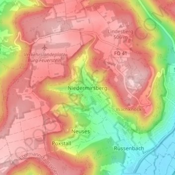
Name: Niedermirsberg topographic map, elevation, terrain.
Average elevation: 1,424 ft
Minimum elevation: 938 ft
Maximum elevation: 1,739 ft
Das im Süden der Heiligenstädter Flächenalb gelegene Pfarrdorf befindet sich etwa drei Kilometer westnordwestlich des Ortszentrums von Ebermannstadt auf einer Höhe von 349 m ü. NHN.
Other topographic maps
Click on a map to view its topography, its elevation and its terrain.
Poxstall
Deutschland > Bayern > Landkreis Forchheim > Ebermannstadt
Poxstall, Ebermannstadt, Ebermannstadt (VGem), Landkreis Forchheim, Bayern, 91365, Deutschland
Average elevation: 1,368 ft
Ellersberg
Deutschland > Bayern > Landkreis Forchheim > Ebermannstadt
Ellersberg, Ebermannstadt, Ebermannstadt (VGem), Landkreis Forchheim, Bayern, 91346, Deutschland
Average elevation: 1,542 ft
Burg Feuerstein
Deutschland > Bayern > Landkreis Forchheim > Ebermannstadt > Breitenbach
Burg Feuerstein, FO 41, Breitenbach, Ebermannstadt, Ebermannstadt (VGem), Landkreis Forchheim, Bayern, 91320, Deutschland
Average elevation: 1,335 ft
Breitenbach
Deutschland > Bayern > Landkreis Forchheim > Ebermannstadt > Breitenbach
Breitenbach, Ebermannstadt, Ebermannstadt (VGem), Landkreis Forchheim, Bayern, 91320, Deutschland
Average elevation: 1,207 ft
Eschlipp
Deutschland > Bayern > Landkreis Forchheim > Ebermannstadt
Eschlipp, Ebermannstadt, Ebermannstadt (VGem), Landkreis Forchheim, Bayern, 91364, Deutschland
Average elevation: 1,522 ft