Geolocate

Maplewood topographic map

Click on the map to display elevation.

About this map

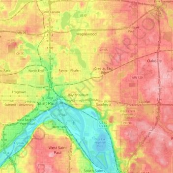
Name: Maplewood topographic map, elevation, terrain.

Location: Maplewood, Ramsey County, Minnesota, United States (44.89078 -93.10597 45.03688 -92.98423)

Average elevation: 915 ft

Minimum elevation: 679 ft

Maximum elevation: 1,099 ft

Ramsey County trails, hiking, mountain biking, running and outdoor activities

Other topographic maps

Click on a map to view its topography, its elevation and its terrain.

Como Lake

United States > Minnesota > Ramsey County > Saint Paul

Average elevation: 919 ft

Crosby Lake

United States > Minnesota > Ramsey County > Saint Paul

Average elevation: 797 ft

Midvale

United States > Minnesota > Ramsey County > Maplewood

Average elevation: 1,001 ft

Gladstone

United States > Minnesota > Ramsey County > Maplewood

Average elevation: 935 ft

Gear up for your next adventure:

📚USA Hiking Guide Books - Top trail guides and map books
📶Vehicle Signal Boosters - Improve reception in rural areas while driving to trailheads
🔋Solar Power Banks - Keep your GPS and phone charged in remote wilderness areas
🩳Quick‑Dry Hiking Shorts - Comfortable and quick‑dry shorts for summer hiking
😴Insulated Sleeping Pads - Compact and warm pads for high-elevation camping

As an Amazon Associate, this site earns from qualifying purchases at no extra cost to you.